New seabed sediment maps reveal what lies beneath the waves

British Geological Survey develops new national-scale BGS Predictive Seabed Sediments (UK) dataset
MARINE ecosystem science and offshore infrastructure will be boosted by a new British Geological Survey (BGS) dataset showing sediment composition across the UK continental shelf.
Characterizing the distribution of seabed sediments (SBS) is critical for a wide range of applications, including mineral and aggregates assessments, habitat mapping, marine ecosystem science, offshore infrastructure siting and monitoring, defence, shipping, and coastal management.
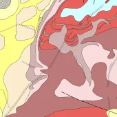
The BGS has developed the new national-scale BGS Predictive Seabed Sediments (UK) dataset aimed at supporting these applications. The dataset comprises four digital maps that portray SBS composition, including a classified map of sediment types, as well as the predicted proportions of sand, gravel, and mud across the UK continental shelf.
Generated with the assistance of machine learning, these detailed maps are based on around 40,000 sample measurements, as well as numerous physical covariates that relate to the spatial distribution of SBS.

Dayton Dove, marine geoscientist at the BGS, said: ‘Understanding the nature of the seabed is fundamental for many offshore activities, from understanding benthic habitats and carbon stores to effectively designing and installing offshore infrastructure, including wind turbines and submarine cables.
‘Seabed sediments lie at the interface between the water column above and the variable geological substrate below. To an extent, they can be considered similar to the soil layer on land, but offshore sediments are exposed to dynamic marine conditions and are, therefore, potentially transitory and mobile over variable timescales, for example, during tidal, seasonal, and storm cycles.
‘We hope that the release of the new BGS Predictive Seabed Sediments (UK) dataset will provide a useful free resource for many users, including researchers, developers, and marine managers.’
The BGS Predictive Seabed Sediments (UK) dataset is now freely available to download under the Open Government Licence (OGL) and can be used in combination with other thematic BGS 250K datasets that are also now available via OGL, such as bedrock geology. It can also be used with more recently produced, high-resolution seabed geology mapping.