3GSM update BlastMetriX UAV software

New software version and analysis tools optimize blast performance and improve safety
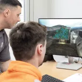
AUSTRIA-based 3GSM GmbH, developers of software that optimizes blasting and reduces inherent environmental issues, have announced several significant updates to their flagship BlastMetriX UAV software.
Advancing blast performance and safety, the new version improves communication with smart drills, offers face-profiling enhancements, and delivers more sophisticated drill pattern analysis. Customers with an active update license will automatically receive these new features inside the BlastMetriX software, or they can be ordered separately.
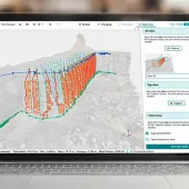
The enhanced drill pattern analysis tool provides heat mapping of drilled borehole deviations for simple visualization of differences between ‘as planned’ and ‘as drilled’ patterns. Semi-automatic mapping of linear rock mass features is imported into the blast plan. By providing enhanced burden and spacing information, the software allows users to adjust explosive amounts in each borehole to account for irregularities. The software captures information from each blast and allows users to go back and review historical data to correct issues in the field.
Updates to the IREDES (International Rock Excavation Data Exchange Standard) interface improves two-way data communication between BlastMetriX UAV and smart drills. It now allows for the import of measure-while-drilling data, such as drill penetration rate and air pressure, to map the subsurface geology of the borehole. The software shows, at a glance, the geology and burdens from borehole top to bottom and out to the free face. The program is compatible with all major drilling equipment manufacturers.
Incorporating the ShapeMetriX system for generating and assessing 3D images, new geological mapping integration allows users to better visualize dips, strikes, seams, and voids throughout the drilling pattern. The software can characterize irregularities in the face, which are projected back through the borehole, allowing for more precise loading of the borehole, and improving blast safety. Moreover, the underground volumetric measurements tool inside ShapeMetriX now provides the determination of precise volumes in a generalized manner.
With the aid of aerial targets or standard BlastMetriX targets as reference points, the software imports images from a calibrated DSLR camera or unmanned aerial vehicle (UAV) to capture 3D face profiles quickly, safely, and accurately for enhanced visualization of the blast area. Multiple data-rich overlapping images generate hundreds of thousands of data points for accurately characterizing the topography of the surveyed area and creating a 3D face profile.
According to 3GSM, BlastMetriX UAV gives technicians the confidence that the blast will perform as designed to mitigate flyrock issues, high air-overpressures, excessive vibration, poor fragmentation, below-par cast, wall damage etc. Through blast design optimization using the product, operations can realize significant benefits including improved fragmentation, higher crusher throughput, and reduced drilling manpower requirements, with the scalable software allowing companies to integrate as much or as little technology as required.