New BGS GeoIndex viewer released for user testing

Premium map-viewing application given a major upgrade and made available as a beta release
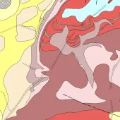
THE British Geological Survey (BGS) premium map-viewing application has been given a major upgrade and made available as a beta release. First launched in July 2000, the BGS GeoIndex is a professional digital geological map application and receives more than one million views each year.
The current iterations of the GeoIndex Onshore and GeoIndex Offshore applications are now 10 years old and approaching the end of their technical lifespans. The transition to the updated viewer has allowed BGS to unify the platforms into a single, streamlined tool and increase awareness of the geological data available from BGS.
Alongside the integration of onshore and offshore data, the new GeoIndex beta release includes a number of other notable additions. The refreshed and upgraded user interface has been designed to enhance the user experience, with improved find and filter tools to make it easier to access the relevant data.
In addition, direct links to full Discovery Metadata records have been added to provide deeper insights and there are expanded basemap options, including the latest Ordnance Survey maps and high-resolution satellite imagery.
The beta release also includes core geological data layers, such as 625K- and 50K-scale digital geological mapping and borehole datasets, to allow for focused user testing. BGS is also looking at eventually streamlining some of the other currently available data layers as part of the review, to ensure the new platform is as user friendly as possible.
Steven Richardson, BGS geospatial applications developer, said: ‘The BGS GeoIndex is our flagship map viewer, and we’ve spent the last few years planning how we can improve the application for our users. We are excited to share this beta version for testing and to gauge users’ reactions, and hope the updated interface will bring many welcome usability improvements.’
The British Geological Survey would welcome user feedback during the beta phase, with comments submitted through the GeoIndex online feedback form.
BGS stresses that commercial and research level users should continue to use the existing BGS GeoIndex onshore and offshore applications for professional use until the new platform is formally launched.