Visionary Geomatics
First published in the March 2019 issue of Quarry Management
Simon Briggs, managing director of Geodime Ltd, examines the impact of new survey technologies on mining and quarrying in the 21st Century
In 1998 the Royal Institution of Chartered Surveyors (RICS) introduced the term Geomatics to describe what was formerly known as its Land and Hydrographic Surveying Division. This was and remains controversial. It was partly a marketing ploy to appeal to new cohorts of undergraduates around the world, but fundamentally recognized a change in the role of the land surveyor. Survey technology was and still is advancing quickly and software is keeping pace. The applications and demands for spatial data are now huge and the surveyor’s workload is evolving around a plethora of innovative new ways of collecting, managing and manipulating such data.
This article looks at how surveying is likely to evolve in the next few years within the mining and quarrying sector and how the role of the land surveyor must change with it.
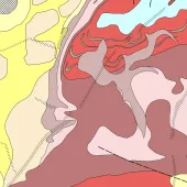
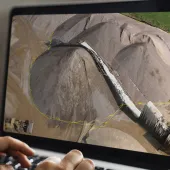
There is a clear move towards the presentation of spatial data as virtual reality. The key to this is the point cloud – 3D points, and a lot of them. Increasingly, survey sensors are moving towards collecting this style of data. It began with the high-definition laser scanners of the survey world and face-profiling lasers of the quarrying world. High-specification total stations now have a scan option. Underwater multi-beam sonar devices collect a vast amount of points. Now scanning has evolved to mobile mapping. There are hand-held devices using SLAM (simultaneous localization and mapping) technology that allow real-time scanning while moving. More sophisticated vehicle-mounted mobile systems combine GPS, scanners and photogrammetry in one unit, allowing incredibly fast surveying, all to create that point cloud.
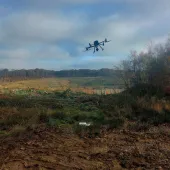
Then there are unmanned aerial vehicles (UAVs). These are just vehicles for putting sensors in the air, and for the quarrying industry the primary survey role is photogrammetry and LiDAR (light detection and ranging), but high-definition scanners can also be UAV mounted. All are either directly or indirectly producing that point cloud.
Photogrammetry deserves more than a brief mention. This was really a lost science until the development of digital photography and fast computer processors, and yet photogrammetry is responsible for much of the Ordnance Survey’s mapping in the last century. Photogrammetry relies on the identification of matching points in overlapping photographs, which can then be accurately positioned in 3D space. If you use ground control, or preferably have a robust GPS system that knows the exact position of the UAV when the images are taken, then you can fit the survey to a known grid.
Photogrammetry really tops technologies in our current industry where we have bare surfaces and great geometry to run the algorithms. The resultant point cloud is clean (compared with scanning) and comprehensive. At Geodime, we have carried out UAV surveys in rain and snow with poor visibility and in blustery winds over the last few weeks, and the results were still excellent. We would probably not have got out of the car with a scanner!
From the point cloud it is possible to create a dense and accurate 3D mesh and digital elevation model and from there a scaled orthorectified photograph. This, counter-intuitively, is the last part of the process. The orthophoto comes from the mesh or digital elevation model. As these may well not be reduced down to ground level, vegetation will cause distortion (often seen in perimeter roads) but the area of survey interest will be accurately represented as long as the data is processed correctly.
To really reflect reality, each point in a cloud needs to have a colour value as well as a position. LiDAR and some mobile scanning systems do not have that capability, and some software cannot handle the colour. The easy answer is to drape the orthophoto over the digital terrain model, but some software will allow the use of the orthophoto to extract the colour for each point in the cloud, thus moving ever closer to reality.
The mesh is a really important deliverable and allows the running of automated analytical tools. With the right software and with ease, the quarry manager can interrogate the survey direct without the need for scale rules, paper plans and phone calls to the surveyor to add more levels. Identifying protection bunds that are too low or even calculating rudimentary stock volumes can be done with very limited survey knowledge. The models are fairly crude at the moment to facilitate access over the Internet with the need to decimate (simplify) the mesh, but as processing power increases and the Internet improves these will become increasingly complex.
GIS, and more specifically Building Information Modelling (BIM), has become a hot topic in the wider survey world, even if it does not mean much more than adding information to a plan. GIS, however, is an area that has left our sector behind somewhat. Would it not be useful to be able to click on a motor on a digital plan and see its voltage, service history, safe working temperature, exact position and then to be able to pre-programme a UAV with thermal cameras to visit and check the running temperature as part of routine maintenance?
What of the future? We are in the age of the UAV so the miniaturization and falling price of the airborne sensor will allow for more innovative data collection, highly relevant to our sector. There are sniffer systems for landfill gas, multi-spectral sensors for vegetation health monitoring, hyperspectral sensors that have great applications for geology and geotechnical assessment (used at the moment to detect hairline microscopic cracks in wind turbines). Indeed, just about anything you can dream up can be fitted on a UAV.
As for deliverables – if we are working with virtual reality, do we really need to keep producing line drawings, with tadpoles and contours to allow the viewer to interpret the plan in 3D in their mind’s eye (something that a lot of our clients struggle with) when actually we can just give them the finished article? As surveyors, can we finally stop throwing away a huge amount of the rich and diverse data we collect just so that we can get it into a format that our clients can handle?
Will land surveyors as we know them become redundant in our industry? To some extent, yes.
Survey devices are now developed to be more automated so that they can be more easily used by non-surveyors. The huge rise in GIS data collection is driving this. UAV systems can be operated easily and the imagery sent off for processing. Do we need £30,000 survey-branded drones when DJI and similar popular brands will do the job just as well? Analytics of meshed 3D data run on simple systems designed for quarry managers have already been discussed.
The key is that all of this exciting innovation, which absolutely will revolutionize the quarrying industry, has geospatial data at its core and it is the surveyor that has the best expertise to understand and guide this. The challenge for the geospatial professional is to embrace this change and take a lead. As a company, Geodime added the strapline ‘Visionary Geomatics’ some years ago. We are noticing now that whilst many consultants are happy to carry on with workflows unchanged for years, some are evolving and developing exciting ways of using the new technologies to offer geospatial solutions in very innovative new ways. Geospatial professionals are able to add real value to the spatial data, and profit margins are finally growing.
This leadership is really necessary while the industry is in the fairly early stages of adopting technologies. It is easy to get something that looks good from a UAV, for example, but far harder to actually produce an accurate point cloud. Ground control is very misunderstood – photogrammetry requires a level of expertise and on-board differential GPS must be robustly checked. If the camera is not stable and there are calibration errors it does not matter how good your on-board positioning is, and if your camera has a rolling shutter, can you adjust for this? Then, when processing, can you classify the point cloud to allow extraction of pertinent cloud data without clutter?
2D photogrammetry can be easily produced for clients such as farmers by using Internet-based processing software, but the 3D and complex topographies that we have to cope with requires an added level of expertise. Calculating stock volumes on a flat floor is easy, but less so when you have complicated base topography.
Of course, we are not using these technologies in isolation. Creating a full virtual model of a quarry might require UAV photogrammetry, terrestrial photogrammetry, total station surveys, GPS, LiDAR to model faces obscured with vegetation, tripod-mounted or mobile scanning of the plant, and multibeam sonar for the silt ponds. And it may be that all of this has to be to a local grid rather than OS control. Combining these data sets into a seamless model is not for the faint-hearted (nor for a well-known brand of computers as it happens!). Furthermore, the data may come from different sources in different formats and, unless well managed, without appropriate positional control.
Further ahead, survey data collection will become more automated and a routine part of the workings of any large mine or quarry. UAVs are here to stay with their unique and clear viewpoint. However, LiDAR is also becoming ubiquitous with its use in autonomous vehicles. In the near future it is likely that mobile quarry plant will be equipped with cameras and scanners to continually collect data to be fed into a central processing unit that will facilitate an accurate real-time virtual 3D model.
This will be at the core of the quarry’s management system. It will allow fast and automated decision-making to maximize production and reduce costs by optimizing the use of all plant. More specifically, comprehensive and precise spatial data, continually updated but tracking changes can generate safety alerts – eg when rocks are about to fall from a face, a stockpile has reached its maximum height or a rotational slip is developing on a tip. It can also reduce fuel costs by optimizing vehicle movements and switching screen decks to ensure that the production of certain materials matches sales orders.
Thus, the future of the geomatics professional, if not the traditional land surveyor, is an exciting one. Fundamentally, throughout all of this change the core disciplines and principles of the survey profession still hold true today. The professional that has these as a foundation and can truly think out of the box has a very bright future. For further information visit: www.geodime.co.uk
- Subscribe to Quarry Management, the monthly journal for the mineral products industry, to read articles before they appear on Agg-Net.com