Subsurface Imaging
Characterizing sand and gravel deposits in three dimensions
By Jonathan Chambers, British Geological Survey
High-quality site investigation information is an essential prerequisite for accurate reserve estimation, effective quarry planning and efficient operations. To this end, the British Geological Survey (BGS) has been developing state-of-the-art ground-imaging technology for sand and gravel deposit investigation through the ‘IMAGER’ (Investigation and Monitoring of Aggregate Deposits Using Geo-Electrical Resistivity Imaging) project.
The project has been funded by the Mineral Industry Sustainable Technology (MIST) programme, in partnership with Tarmac, Hanson, Lafarge, CEMEX, Aggregate Industries and the Minerals Industry Research Organisation (MIRO). Its primary aims have been to demonstrate electrical resistivity tomography (ERT) as a nationally applicable high-resolution imaging methodology for non-invasively characterizing sand and gravel deposits, and to raise awareness within the mineral industry of the economic and environmental benefits of applying ERT technology.
Why use ERT?
ERT is an imaging technique that is analogous to many of those used for medical applications, eg magnetic resonance imaging (MRI) and electrical impedance tomography (EIT), and, as such, allows the user to see inside the object or region of interest, thereby reducing reliance on invasive investigations. In the context of sand and gravel deposit characterization, ERT is sensitive to compositional variations in the subsurface and can, therefore, be used to distinguish between different material types, eg clean gravels and clay bedrock, and to spatially map three-dimensional structures, such as overburden and mineral volumes, and quality variations within deposits.
The principal advantage of ERT is that it provides fully spatial/volumetric information; this complements intrusive sampling methods, which typically provide information only at discrete locations. For complex sites that display significant geological variation between boreholes, the spatially continuous data provided by ERT can be particularly valuable. Likewise, ERT offers the possibility of providing ground information at sites that are undrillable, eg due to a high proportion of cobbles and boulders. Deployment of ERT is also possible in many areas that can be difficult to access for drilling, including woodland, cropped fields, soft or marshy ground and steep slopes.
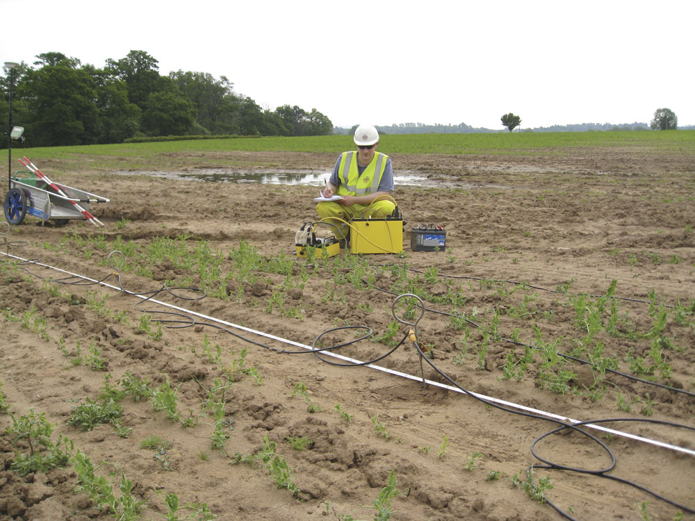
Survey equipment
The survey equipment used for ERT surveys is lightweight and portable and can be deployed from an estate car or 4x4 vehicle. To undertake a survey, lines of stainless steel stake electrodes are positioned along the ground surface and connected by multi-core cable to an ERT imaging system, which is used to automatically run a predefined measurement cycle, typically consisting of many thousands of measurements. Survey lines can be anything from a few metres to hundreds of metres with depths of investigation of several tens of metres. For site-scale surveys, a typical field crew will consist of between two and four people, and will include a geophysicist and field assistant(s).
Most of the costs associated with ERT field surveys are related to staff time. Preliminary ERT results for individual survey lines can be produced in the field within moments of data collection finishing, using image-reconstruction software running on a field laptop. This provides an initial assessment of data quality and significant subsurface structures. Detailed data processing, topographic corrections and visualization are undertaken post-survey.
Two fundamental survey modes can be used; these are 2D and 3D ERT. The simplest type of ERT survey is 2D and is undertaken using a single line of electrodes, the data from which is used to construct a vertical 2D slice through the subsurface. 3D surveying is also undertaken using lines of electrodes, but requires multiple line locations in close proximity to one another that are surveyed consecutively; the measurements from each line are merged into a single dataset, which is processed to produce a 3D image.
Rapid reconnaissance
For rapid reconnaissance surveys, 2D ERT is an ideal tool. Coverage of hundreds of metres to a few kilometres per day is achievable with a crew of two or three people. Results can be delivered shortly after the survey in the form of a descriptive report and annotated sections.
Surveys can be used as an initial reconnaissance tool to provide a broad indication of geological variability and to identify drilling targets. Equally, 2D imaging can be used post-drilling to provide improved characterization in areas where drilling data has not provided sufficient lateral resolution of the geological structure.
Recent examples of 2D ERT reconnaissance survey include: characterization of ‘feather-edge’ deposits in Upper Thames terrace deposits which displayed very significant thickness variation and were, therefore, difficult to characterize using intrusive methods alone; spatial definition of a channel structure incised into bedrock; mapping the spatial extent of clay interburden in a river terrace deposit; overburden thickness determination at a site with dipping Folkestone Formation bedrock sands below a clay capping layer; and mapping compositional variability in heterogeneous glacial sand and gravel.
Detailed investigation
Fully volumetric images of the subsurface generated using 3D ERT are a powerful tool for detailed site investigation and reserve estimation. Coverage rates are dependent on survey design and ground conditions, but typically are of the order of 1 to 3ha per day. These surveys are best suited to undrillable or complex deposits for which point sampling information does not provide sufficient resolution. 3D imaging does not replace intrusive methods (ie boreholes/trial pits) because physical sample recovery and analysis is necessary, and intrusive data is required to calibrate and interpret the geophysical images. However, through improved characterization of the deposit, ERT has considerable potential to improve the targeting of intrusive sampling and reduce the number of boreholes required.
3D ERT has now been demonstrated on a number of sand and gravel deposits in the UK, including highly complex river terrace deposits that had proved impossible to adequately characterize using conventional means, and glacial fan deposits that were impossible to drill due to the high cobble and boulder content. The images have been analysed using interactive visualization software that allows the geophysicist or geologist to appreciate fully the 3D nature of the deposit. It addition, the software can be used to calculate mineral or overburden volumes, thereby contributing directly to the process of reserve estimation and quarry planning. Integration of the technology with current practice has been achieved through extracting layers (eg base of mineral) from the 3D images in a format compatible with industry standard software, such as LSS.
National applicability
To date, ERT surveys have been carried out on a broad range of important economic deposits in England and Wales and were shown to be an effective ground investigation technique for all of the sites considered, due to the good resistivity contrasts observed between mineral and bedrock. Economic sand and gravel deposits are, by definition, relatively clean (ie low clay content), and are, therefore, typically more resistive than the weathered mudstone (eg Mercia Mudstone Formation), chalk and clay (eg Oxford and London Clay) bedrock that underlies many important UK deposits. The success of ERT in the diverse range of geological settings considered so far greatly increases confidence that it will be more generally applicable to UK sand and gravel resources.
Good practice
Geophysical surveys should always be designed, executed and interpreted by skilled operators who are able to assess the suitability of the technique for the given problem, and are able to communicate the likely limitations of the technique to the client. In the case of ERT, it is important to indicate the likely resolving capabilities for a particular survey design (the image resolution decreases with depth), and to highlight potential ambiguities in interpretation due to, for example, insufficient resistivity contrasts between material types. An assessment of data quality and modelling errors should always be made and reported; these are essential indicators of the confidence that can be placed in the survey results.
ERT should not be used as a stand-alone tool for site investigation; it is good practice to use intrusive data and any other available geological or engineering information to interpret and calibrate the geophysical images. Instead, ERT should form a component of a structured site investigation programme. If used as an initial reconnaissance tool as a means of identifying drilling targets, the ERT images should be reassessed after ground-truth information becomes available. In this way, additional information may be gained from the original ERT through improving and refining the initial interpretation of survey results.
Conclusion
Electrical resistivity tomography is a ground-imaging tool which can complement conventional point-sampling approaches by providing fully volumetric information on subsurface conditions. Despite the potential benefits of ERT, it has not yet been routinely applied by the minerals industry to sand and gravel deposit investigation. This is due, in part, to unfamiliarity with the technique and a lack of demonstration studies. Recent work by BGS and industry partners has now demonstrated ERT as a cost-effective site investigation tool across a range of economic deposits, both for rapid site reconnaissance and detailed reserve estimation. This approach is particularly beneficial at sites that are difficult to characterize using conventional approaches. It is hoped that the necessary evidence base now exists to facilitate the take up of ERT, so that the industry can benefit from the latest advances in ground-imaging technology.
For further information contact Jonathan Chambers at BGS on tel: (0115) 936 3428; or email: jonathan.chambers@bgs.ac.uk
This article is published with the permission of the Executive Director of the British Geological Survey (NERC).
