Predicting Restoration Water Levels in Quarries
First published in the May 2022 issue of Quarry Management
Why it is so important for a successful restoration scheme?
By Lee Clarke, principal hydrologist and hydrogeologist, and James Dodds FIQ, water-management specialist, Envireau Water
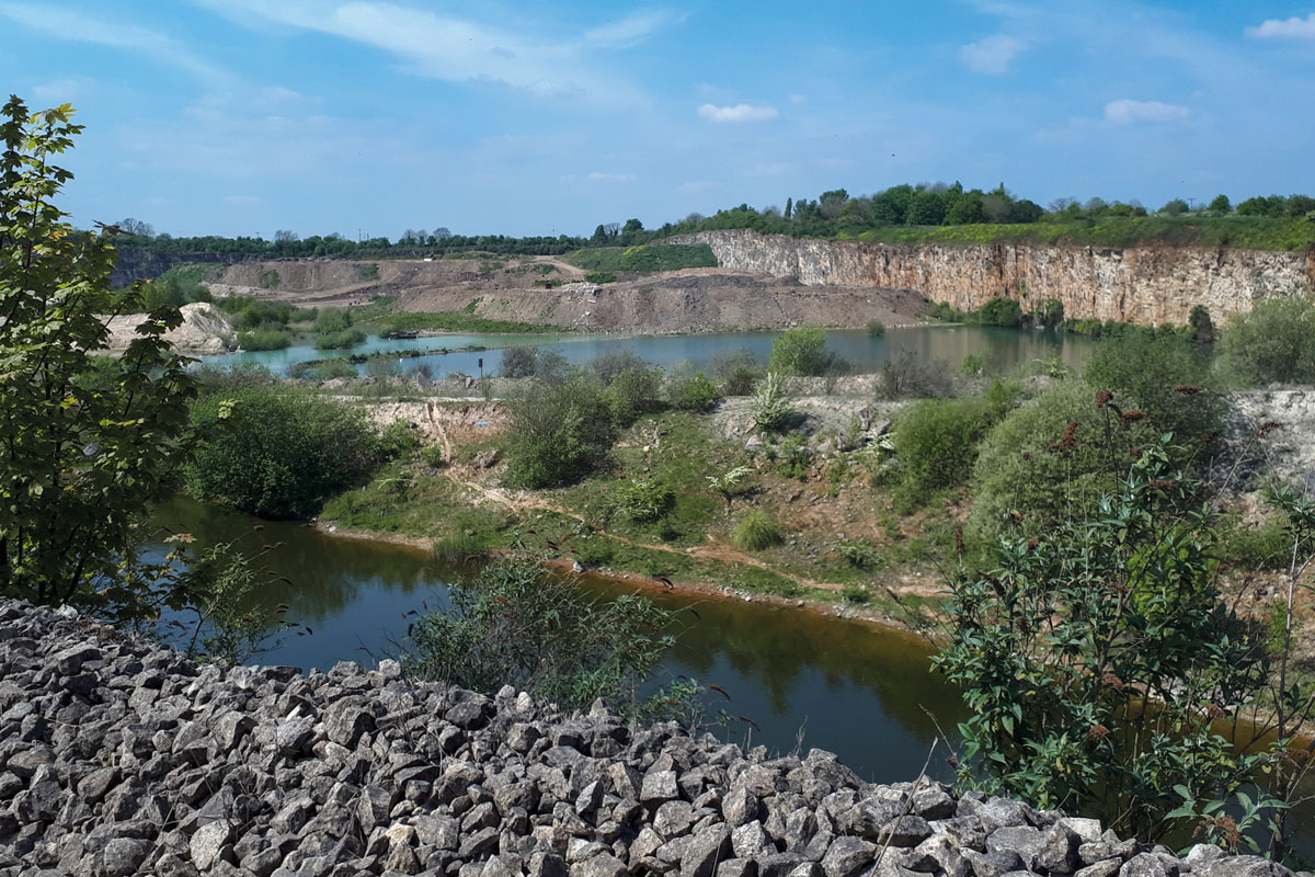
Quarry restoration is an increasingly important component of the UK’s biodiversity requirements and water-based restoration is one of the commonest approaches. It may sound obvious, but to be successful a water-based restoration must fill with water and the level or depth of water must be right for the biodiversity objectives. Failure to achieve the correct depth or level of water can lead to expensive remediation work, non-compliance with planning conditions, and the wrong ecology developing. To get it right it is crucial to understand the hydrogeology, hydrology, and inflows and outflows from the quarry void so that restored water levels can be controlled, be that with natural controls and letting nature take its course or with engineered control structures.
What does it take to successfully predict restoration water levels?
For a successful restoration scheme, predicting restoration water levels is a crucial factor. This can be tricky if there are limited data available on groundwater levels and inflows to the system, or incorrect assumptions made on water level controls, or even no account or consideration given to control of final levels at all. It is common in the case of long-standing quarries that original groundwater levels were never established. As restoration projects come in all shapes and sizes, with various aspects that will influence the final water level, it is important to consider and take account of several factors.
Geology
The geology of the quarry is critical in determining the restoration lake water balance, filling time and final water level fluctuation. Sand and gravel, high-PSV grit, volcanics and limestone will all result in very different behaviours.
Setting
A quarry situated on a river floodplain or river terraces will be subjected to different influences to a quarry on elevated ground or a hillside.
Groundwater
Linked to geology, the groundwater system will determine how much water will enter and leave the lake through the bedrock. Low-permeability strata will result in a lake water balance dominated by rainfall, evaporation, and possibly transpiration, whilst high-permeability geology will buffer water levels in the lake by water moving into and out of groundwater storage.
Restoration material
It might surprise some readers to hear that it is common for the above points to be thought about, only for the void to have restoration material (usually of low permeability) placed in it, effectively sealing the void, and totally changing the void water balance. This can result in a void not filling, or filling very slowly, or overfilling and causing flooding.
Drain point
The drain point is the critical aspect of predicting a final water level. The drain point can be simple where the geology is of low permeability. It will form at the lowest point on the quarry rim. It is important, however, that this overflow point is designed and engineered so that it discharges water at the appropriate rate and in the right place. More complex drain points exist when the geology is the control. This can occur in permeable quarries, or where there are permeable layers. Perched aquifer systems complicate the picture.
Lake water balance
The lake water balance ultimately controls the water level and water level variation. If left to its own devices the water level will respond to rainfall and evaporation. If the restoration calls for a constant water level, then a fixed drain point will be required, below the minimum natural water level. That lake will then have a variable discharge rate, rather than a variable level.
Why does it matter?
Apart from the obvious, that the water level is critical to the landscape design of the lake, in most cases because a fixed water level will be required, there will be a discharge from the lake. The lake also provides the opportunity for the storage of ‘flood’ water and the slow release of this water to provide betterment of flood risk downstream. In these cases, it is critical that the discharge rate from the lake is understood, whether the discharge is predominantly groundwater baseflow, and the quantity of runoff that is received in normal rainfall events as well as extreme storms. The outflow from the lake will need to be designed to accommodate baseflow and restrict storm discharge to an appropriate greenfield runoff rate.
Preparing for design
It is not only a good hydrogeological conceptual model that is important in predicting restoration water levels in quarries; collecting and recording the correct data helps to inform the conceptual model too. This information gathering needs to start at the beginning of the quarry’s life (if possible) and continue through to the end. Site investigation works, groundwater level monitoring, including baseline or pre-development monitoring, monitoring during dewatering to understand groundwater drawdown, and post-development monitoring for groundwater rebound, all provide critical data. Recording groundwater inflow horizons or seepage zones during operations will help develop an understanding of where water enters the quarry, and which are the important levels. It is wrong to assume that the water will rise to the highest inflow level. Measuring and recording the dewatering and discharge rates and volumes during operations provides an important set of information. Where infilling is proposed, even if it is only landscaping or where sidewalls have been sealed, the material and placement should be recorded so that the interaction with groundwater inflow can be considered. Not every extraction cell across a sand and gravel quarry is treated in the same way, and the people that worked that cell may not be around when the restoration is being implemented.
Bringing it together
Maintaining a good data record that includes data gathered from the design of the quarry through to restoration is key for a successful lake-based restoration scheme. The data should be brought together in Input-Storage-Output (ISO) models, surface water or drainage models, rainfall and climate models, or groundwater models. These models can be simple calculations, spreadsheet analytical models, or occasionally complex numerical models. Whether the data are used for simple analytical approaches or more complex numerical models to predict restoration water levels, the key is that the more high-quality data there are available, the higher the confidence there can be to accurately predict the restored water level and its variation, or to fix the level and understand the variation in discharge. Depending on the desired outcome, natural controls or engineered control structures can then be designed with some degree of certainty.
Data-gathering exercises may seem like a waste of precious time and money but getting the restoration water level correct the first time around will save time and costly corrections at a stage in the quarry lifecycle when it is not generating income, should the final water level not be the same as that assumed in the restoration concept or design. All too often is a restoration concept presented in a planning application that looks great on paper but has not been thought through in terms of the local hydrology, hydrogeology, and the quarry development plan. To avoid unexpected costs and delays, ensure high-quality data are gathered and the right people are involved at the right time to understand the local hydrology and hydrogeology influencing the final lake level.
- Subscribe to Quarry Management, the monthly journal for the mineral products industry, to read articles before they appear on Agg-Net.com