Drilling accuracy and efficiency with Sandvik TIM3D

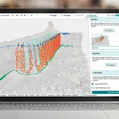
Sandvik are launching a new 3D drill rig navigation system for surface drilling. The TIM3D system uses satellite navigation to guide the starting point and the correct course of drilling in accordance with the drilling plan.
Bringing drill rigs into the realm of 3D machine automation, TIM3D is an operator aid consisting of three essential operations: rig navigation, feed alignment and drilling. It significantly improves drilling accuracy and efficiency in quarrying, construction and open-pit mining applications.
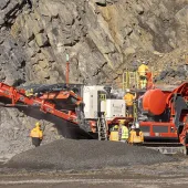
According to Sandvik, the TIM3D navigation system improves hole quality and hole position accuracy, which translates into better fragmentation and a decreased amount of boulders and fines. This, in turn, results in increased efficiency in the downstream production process, both in crushing and loading and hauling.
The system also eliminates the need for surveying and hole marks, thereby also removing the risk of marking errors and significantly speeding up drilling. Thanks to a modern and clear user interface, the system is easy to use.
Based on multi-satellite RTK GNSS navigation, TIM3D is compatible with GPS and GLONASS satellite systems. The navigation uses drilling plans made with either standard office programs or via the system itself. The plan containing the target co-ordinates in three dimensions, in IREDES standard format, is imported to the rig using a USB memory stick. Local base station or VRS correction keeps navigation accuracy to within 10cm.
TIM3D makes the drilling process easier for the operator. The system compares the position of the drill bit with the planned hole position and guides the operator to the correct starting point of the chosen hole. During drilling, the operator can follow the penetration rate and hole depth, distance to target, number of required holes and current feed alignment. Furthermore, drilling stops automatically at the target depth. The system also shows the status of the holes using color codes.
In addition, TIM3D allows the operator to deviate from the drill plan if necessary, eg due to an infeasible planned starting point. Despite the modification, the hole bottom remains as planned and the TIM3D system automatically calculates a new course based on the actual starting point of the hole.
The drilling data (the actual parameters ) are stored in the system memory from where they can be imported to various programs, such as blasting simulation. The data includes a quality report, position and depth of the drilled holes, drilling time, and start and end points.
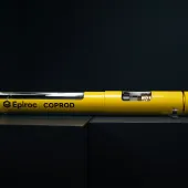
The TIM3D navigation system is available for Sandvik DPi and DX series surface top-hammer drill rigs.