Water-based Quarry Restoration
By P.A. Ellis, C.C. Leake and M. Hammond, Hafren Water
Sub-water table mineral extraction has been undertaken for hundreds of years resulting in the creation of large areas of wetland and numerous water bodies. Many of these have significant ecological and public amenity benefit, such as the Norfolk Broads, and are important resources at regional and national levels. Historically, most site restoration was generally passive and unplanned. However, increasing public awareness, greater understanding of the water environment and progressive tightening of planning regulations and European Union (EU) directives have placed a greater emphasis on the optimization of water-based restoration design.
Hafren Water have undertaken, through the Minerals Industry Research Organisation, research into water-based quarry restoration to examine the physical and practical constraints on various restoration schemes. The research focused on several sites in North Yorkshire, each in different settings and stages of restoration.
Mineral companies often have a considerable land bank (freehold or leasehold) over which they have control or influence. This includes currently operational sites, restored areas, proposed future extraction areas and land that will never be worked. An integrated approach to the management of these areas, and those of adjacent operators, will provide for an optimum after-use strategy.
Strategic overview
In order to facilitate the creation of large viable areas of specific habitat and undertake major flood-alleviation or water resource schemes, a strategic approach to planning is required, informed by relevant data, of which the hydrogeology forms a key component. At present, the approach to restoration is frequently reactive and ad hoc, with each planning application often assessed in isolation. County councils and conservation bodies are developing a more strategic approach, with targets set for restoration objectives to maximize the benefits of a co-ordinated approach to quarry restoration.
Habitat creation
Water-based quarry restoration encompasses both perched and sub-water table open water bodies, and areas of habitat dependent on wet conditions and/or subject to frequent inundation, such as fens, mires, reed beds, wet grassland and woodland.
Key hydro-ecological controls on habitat creation include:
- water table and capillary fringe elevation and fluctuation relative to ground level
- the composition and hydraulic characteristics of the substrate material and the underlying geology
- water quality and source
- site water balance and soil moisture availability
- depth, duration, frequency and seasonality of inundation.
The hydro-chemical environment, including acidity, base content (eg groundwater discharge from limestone) and availability of nutrients, is extremely important.
Wetland habitats are successional and require a degree of management, including grazing, mowing, harvesting, water level control and scrub clearance, to sustain them in the desired state. Fen will produce peat that over time may develop into bog. Marginal reed beds may gradually encroach from lake margins, forming organic-rich substrates and peat for successional vegetation. The climax habitat will generally be wet woodland, although on the timescale considered for quarry restoration, which appears to be generally less than 30 years, this is unlikely to occur. Given the dynamic nature of the wetland environment, a mosaic of different habitat types often develops and represents a desirable restoration target. However, each habitat created should be of sufficient size to be viable to sustain itself and the associated ecology. This said, some habitats, particularly some fen types, are now so rare in the UK that creation of even small amounts will add significantly to the national resource.
Historical context
An understanding of the historic context of an area prior to mineral extraction allows habitat restoration relevant to the local landscape. For example, a 92% reduction in the historic wetland habitats of the rivers Swale and Ure, related to widespread agricultural land drainage, can be traced through archived evidence.
Regional characteristic types of wetland include: meres and associated wetlands formed in deeper basins in glacial till; peatlands formed in shallow basins in glacial till; open water transitions associated with gypsum sink holes; valley fens irrigated by springs and seepages; floodplain fens; and raised bogs. Many of these could represent important restoration objectives.
For reasons including the widespread use of fertilizers, the plant species and communities most at risk of extinction in the study area are those that require low-nutrient conditions. In this regard, quarries represent excellent opportunities for the creation of scarce low-nutrient habitats. Nutrient-poor substrates, eg subsoil, sand and gravel or bare rock, can be used instead of replacing the stripped, often nutrient-rich, topsoils. A low nutrient content in the water supply is also desirable.
Target habitats
The habitat created needs to be achievable and appropriate for the local area. Information on what to consider may be derived from the regional or local Biodiversity Action Plan (BAP). English Nature (now Natural England) and the RSPB are in the process of constructing guidance on regional/local habitat potential based on a GIS system accessed via the Internet.
Reed beds
Reed beds are good for bird habitat and, although not as rich in biodiversity as fens, have several advantages in terms of habitat creation. The creation and management of reed beds is fairly well understood; they do not need to be spring-fed, as is the case with many fens, and they produce peat, which potentially forms a substrata for future fen development. Reed beds can grow in deeper water than fens, requiring less imported fill material. Reed beds can also be created where there is a reliable water supply sufficient to maintain water levels of up to 30cm depth in spring. Water levels must be low enough to promote establishment in the early stages but high enough to discourage competition from other species.
Fens and mires
Restoration may be used to create the conditions for growth of a range of fen types dependent on different hydrological factors, particularly where peat material is available. Fens may often be kept wet by high groundwater levels, potentially characterized by vertical movements in the water table. Different target communities will reflect varying substrate, water chemistry, nutrient status and landscape contexts.
Seepage habitats
Seepage habitats are rare and localized, and associated with continuous percolation of groundwater at or just below the surface around springs or flushes. Potentially, these could be created in restored quarries by using springs opened up in exposed faces or by using seepages where porous overburden lies over impermeable substrates (eg clay or bedding plane surface). Attempts have been made to engineer seepages by circulating water through perforated pipes within a permeable embankment underlain by an impermeable layer. Even small areas potentially have very high nature conservation value.
Fen meadow
A general requirement is a permanently moist substrate of low to intermediate fertility, on sites suitable for mowing or grazing management. Substrates with a significant capillary fringe are often associated with a high proportion of fine material (clay) or organics (peat) and can support wetland vegetation with a water table below surface.
Connectivity with river corridors
The Ure and Swale are among the most significant rivers on the east side of the Pennines because their upper to middle reaches remain relatively unmodified, support important bird, fish and invertebrate communities, and provide habitats with extensive exposed riverine sediments (ERS). ERS support specialized plant and invertebrate communities (including BAP priority species) as well as providing nesting habitat for some waders. Exposed mineral in aggregate quarries provides similar conditions, and potential hydrological connectivity with adjacent rivers (eg side channels allowing controlled flooding) could potentially be used to maintain permanently open gravel habitats.
Seasonally inundated grassland
This is often found on fertile soils with water levels sub-surface in summer. Sites may be designed with a complex topography to cope with, and benefit from, seasonal variation in both groundwater and surface water levels. A topographic gradient incorporating numerous scrapes may come into play over a seasonal range in water levels below which the lakes are relatively steep-sided. The area would provide suitable nesting habitat and food supply for birds at the appropriate times of the year. Annual climatic and seasonal variation in surface water coverage varies significantly over time and maintenance of the seasonal wet grassland coverage is key in maintaining a site’s conservation interest and, potentially, Higher Level Stewardship (HLS) funding.
Open water bodies and ‘bird strike’
Maximum wildlife potential may be derived from open water bodies that have large areas of shallow water (<0.5 m) and complex shorelines with high edge-to-surface area ratios. There is opposition to the creation of open water within 13km of airfields because there may be an increased risk of ‘bird strike’ and damage to aircraft. Where open water is unavoidable, measures to discourage flocking birds are employed, including the use of steep shorelines, tall overhanging trees up to the shoreline, reducing the maximum distance to shore (<100m) and fences along the lake shore. More active measures considered include the use of gas guns, falconry or recorded bird of prey calls.
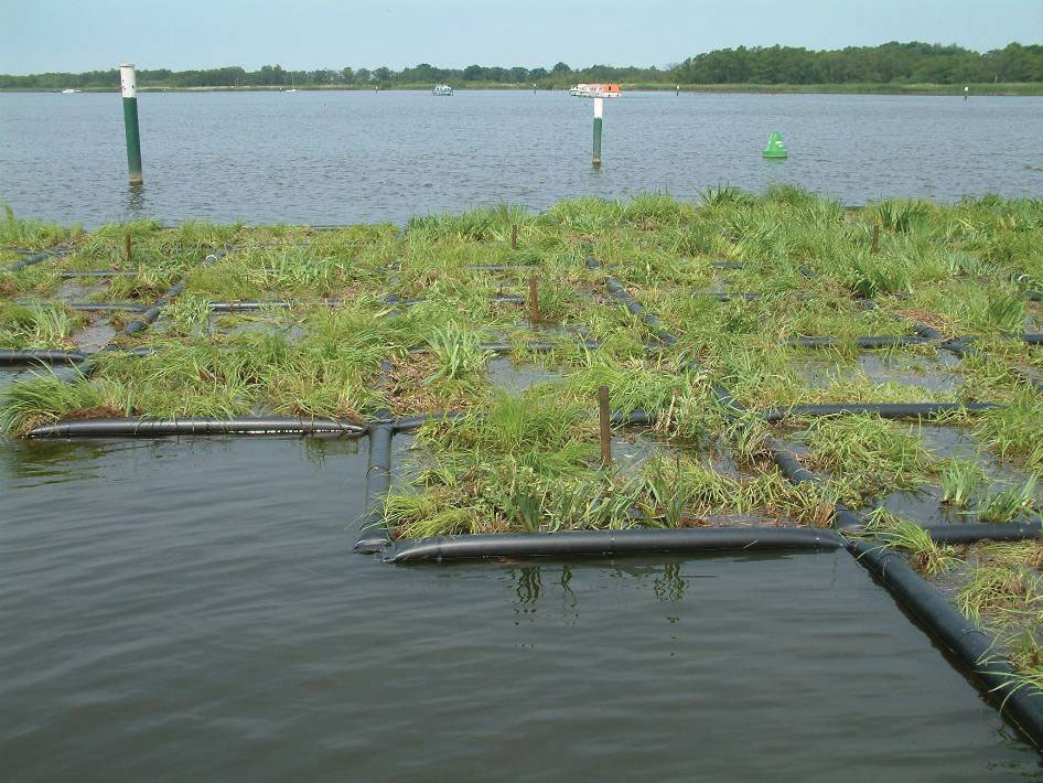
Floating fens
Floating fens offer a method of reducing the surface area of open water and creating priority rare habitats of high conservation value. Natural and semi-natural wetlands include a range of raft-forming vegetation types, where semi-aquatic plants form a floating mat over the surface of open water. These vary from schwingmoors, in which a peat-accumulating raft several metres thick develops over the surface of a deep, steep-sided lake, to carpets of fen vegetation colonizing shallow peat cuttings, which move vertically in response to fluctuations in water level. Natural floating islands may occur when vegetation growth extends outward from the shoreline of a wetland area. As the water gets deeper the roots no longer reach the bottom, and oxygen (and potentially other gases such as methane) in the root mass provides buoyancy.
Sections may break free from the shore during storm events to form islands which migrate around the lake with the changing winds, eventually either reattaching to a new area of the shore or breaking up in heavy weather.
The area beneath these floating mats is likely to be rich in aquatic life. The various types of floating fen/mire are of high nature conservation interest. As well as the conservation interest of the plant communities themselves, floating mires form part of the habitat mosaic used by various wetland birds and tend to be very rich in invertebrates, allowing terrestrial, semi-terrestrial and aquatic species to exploit different niches within the raft.
Other potential benefits include:
- improved water quality
- reduction of open water near airfields
- peat-forming vegetation may provide a carbon sink and a means of offsetting carbon emissions
- protecting and upgrading secondary drinking water supplies
- an increase in mineral recovery. In some cases mineral is being sterilized to provide restoration material for habitat creation, consequently leading to a greater requirement for land elsewhere.
Artificial islands have been employed successfully in other locations and the technology could be applied to quarry restoration.
Site design
Successful restoration depends to a large extent on the geology, the amount of overburden, the base of extraction and the depth of the water table, all of which dictate the volume of fill material available. The height of the restored land surface above the water table is also significant. Sites are normally restored to a mix of agricultural land (previously a planning requirement) and open water. Typically, agricultural land surface is restored to ~1.2m above the mean water table. Restoration back to a wetland habitat with the water table at or near the ground surface generally requires less fill material per square metre, allowing the additional fill material to be used to reduce the areas of open water created. Wetland habitat is of high conservation value versus the often low quality of restored agricultural land, and under the HLS scheme (or similar) it could provide income comparable to an agricultural usage.
Once a desired habitat has been selected and its hydro-ecological controls understood, landforming and control structures may be emplaced in an attempt to achieve the desired result. However, this requires a detailed understanding of the water environment at the site. Current planning application procedures require a hydrological assessment but older permissions and historical sites may have no formal assessment. Monitoring of water levels and inflows/outflows from a site provides essential data for restoration design. In many cases there is a relatively limited monitoring period of data available before restoration designs are undertaken. Regional water level data may be available from the Environment Agency monitoring network, although this is primarily associated with water resources, large aquifers and public abstractions.
Water control is an essential management tool for many nature reserves. Maintenance of the water table at the surface to maintain wet conditions (but not submerged) can allow the development of a fen/swamp habitat.
Flexibility can be incorporated into the restoration design by sub-dividing the restoration into segments with different surface elevations and design water levels. Each segment should have the potential to accommodate a range of water levels by setting upper maximum limits (eg by an overspill) and having a range of surface elevations to cope with fluctuations below the maximum.
The topography of each restored area should be designed to incorporate water level variations. Uncertainty will be inherent in the design, but having a number of discrete areas within the restoration allows flexibility in future management, potentially including the sacrifice of some areas to maintain others.
Water quality
Water quality will vary between different sources and potential exists to isolate the different inputs and utilize them for different purposes within the restoration. Different habitats have specific water quality requirements, often with low nutrient content.
Rainfall has low nutrient and mineral content, whereas agricultural run-off has high nutrient status and pesticides and herbicides may also be present. River and stream courses often receive discharges from industrial sources, sewage treatment works, road drainage and urban run-off, with potentially elevated concentrations of compounds in free phase, dissolved form and sorbed to the surface of particulates. Groundwater may be mineral-rich with varying base content, alkalinity and pH.
Water levels
Monitoring water levels during quarry operations and subsequent to restoration is a key part of developing and adjusting a water-management plan for the site. Monitoring points, such as piezometers, are assets, expensive to install, and should be preserved if possible and ‘handed over’ along with any historical data and borehole logs to the subsequent management of the restored site. Final predicted water levels based on a short run of data, eg less than 5–10 years, are likely to have a lower level of confidence than longer monitoring periods.
Water management plans
A water-management plan should be formulated containing pertinent data. Target water levels (and durations) related to habitat goals would be included within the plan, together with water level control options related to the potential variations within local conditions. Items of income or expenditure related to variations in water level (eg HLS funding, willow clearance etc) would be calculated and optimized. The cost and long-term maintenance of engineered control structures also needs to be included. The cost benefit of the water-management system and plan will frequently pass to the management of the restored area rather than to the quarry operator.
Restored sites have the potential to be entered into the Higher Level Stewardship Scheme sponsored by DEFRA to promote the creation/restoration of certain priority habitats. The scheme is competitive and sites must demonstrate the potential to create and maintain worthwhile contributions to biodiversity. Income is generated on a per-hectare basis for qualifying habitat. For example, income for wet grassland is potentially £360/ha, but without flooding this reduces to £80/ha. The revenue derived is therefore highly dependent on an understanding of the local water environment and the potential variability related to climatic and human factors.
Indications from the research project are that bigger is generally better, rather than the field-by-field approach currently in operation. Large areas allow greater potential for strategic planning, larger (more viable) habitat creation and major works such as flood-alleviation schemes.
However, negative public perception of large areas demarcated for extraction may lead to problems in obtaining planning permission. In addition, these large areas may contain in excess of the ~20-year resource usually incorporated within the minerals plan and permitted to the minerals operators. Concentration of extraction in one area may pose other problems with transport and distribution. Multiple land ownership may also make matters more complex. However, in order to employ planning strategy on a landscape scale, a method of meeting large-scale objectives is required.
For further information contact: Hafren Water, Barkers Chambers, Barker Street, Shrewsbury SY1 1SB; tel: (01743) 355770; email: paul.ellis@hafrenwater.com
Acknowledgements
C. Arditto, Tarmac; D. Park, Lafarge; A. Richards, MIRO; and S. Warwick, Lower Ure Conservation Trust.
