3D Laser Mapping launch SITEMONITOR LIVE

Global geospatial specialists introduce new automated site-monitoring platform for mines and quarries
SITEMONITOR LIVE, a patented LiDAR-powered site-monitoring solution developed by global geospatial specialists 3D Laser Mapping, is set to boost safety, efficiency and productivity in heavy industrial environments.
Comprising three integrated software modules, SITEMONITOR LIVE captures and manages 3D point-cloud data and has been designed to be deployed in mining, quarrying and recycling settings.
The scalable solution is said to mark a major step forward in industrial surveying and asset management, providing real-time data and automated reports for enhanced operational intelligence.
Three modules, +VOLUMES, +BERMS and +SLOPES, each address a specific site problem and, although available separately, can be combined on a single user interface, allowing site-wide visibility in real time.
SITEMONITOR LIVE has been designed to withstand a variety of difficult environmental conditions and comes with an IP67 rating for effective use in dusty and humid environments.
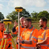
Explaining how the new system aims to become an integral part of site operations, Dr Graham Hunter, executive chairman of 3D Laser Mapping, said: ‘SITEMONITOR LIVE strengthens health and safety policies, taking site teams out of potentially dangerous areas where hazards are common.
‘This product offers the possibility to monitor site-wide operations, from critical slope stability alerts to real-time volumetric calculations, by combining a number of automated systems. As a result, site managers can speed up key processes, while ensuring safety remains a priority.’
Each of the three modules has been developed in response to feedback from customers who need to place safety and productivity in equally high regard – clients who have identified that time-consuming tasks can now be automated whilst reducing cost and risk to on-site personnel.
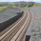
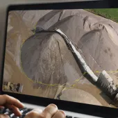
The +VOLUMES module allows site teams to manage stockpiles by data generated from laser scanners, removing the need to measure them manually, while +BERMS is an automated monitoring system that allows a site to continually assess the structural integrity of berms. Suitable for industrial and environmental settings, +SLOPES collects and compares time-series data to identify precursors that could lead to slope failure, such as rockfall and slope displacement.