SICK unveil new sensor developments

LMS1000 and MRS1000 infrared LiDAR sensors offer high-precision and reliable measurement
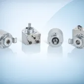
WITH the launch of their LMS1000 and MRS1000 infrared LiDAR sensors, SICK say they have raised the bar in high-precision, reliable distance sensing and measuring, particularly in difficult environmental conditions.
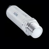
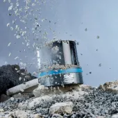
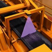
Suitable for quarrying and mining applications, the robust, lightweight and compact sensors are equipped with rotatable connectors, so they can be easily factory-fitted or retrofitted to existing equipment.
The LiDAR units can be mounted on machinery, cranes and gantries or anywhere convenient for optimum viewpoint. The addition of SICK’s innovative HDDM+ (high definition distance measurement) ‘triple-echo’ scanning technology to the LMS and MRS sensors has provide much greater consistency in performance, even when the sensors face adverse environmental conditions.
Heavy rain, snow, mist or dust can lead to false signals where inferior LiDAR sensors or other alternative technologies are used.
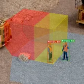
Neil Sandhu, SICK’s national product manager for imaging, measurement, ranging and systems, explained: ‘The triple-echo laser scanning technology means an operator can have greater confidence in the reliability of the information from the sensor, even under difficult environmental conditions. As false signals are almost eliminated, there is much less risk of collisions or errors due to an inaccurate evaluation of the position of objects in the sensor’s field.’
The SICK LMS1000 is an easy-to-use sensor that delivers strong distant and ranging performance, while the MRS1000 four-plane detection capability allows it to be used for more complex tasks, such as multi-level obstructions, boundary mapping and quarry faces.
The former scans in a single plane (with a 275-degree view angle) and up to 64m for a general range of distance detection and ranging applications, with 10 fields allowing several different pre-programmed applications. With the same angle of view and distance, the MRS1000 scans in four planes at different heights, allowing either the height of objects to be scanned in (eg overhanging obstructions) or in-depth mapping using the sensor from an elevated position.
With exceptionally high scanning frequency, the amount of data collected by the LMS1000 and MRS1000 units ensures very high accuracy for the end-user. The triple-echo evaluation technology means that masking effects of snowfall, mist, rain or dust are eliminated from the signal, so that the user can have maximum confidence in the detection and location of rapidly moving objects.