Meadowhill OCCS
Planning for Success
In the prevailing negative political and environmental climate many would have rated the chances of successfully winning planning consent at Meadowhill Opencast Coal Site in Scotland as very low indeed. But Meadowhill has managed buck the trend, initially winning planning permission in autumn 1996 for a 468,000 tonne site, and then again in 1999 when an extension of 875,000 tonnes was granted.
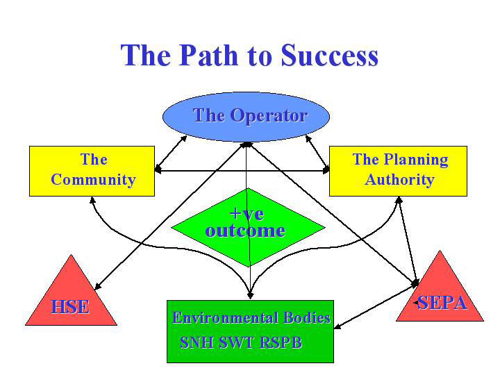
To bring this about involved environmental systems management at its best, as well as partnership between the local authority, regulators, consultees and the community. Achieving a ‘win–win’ situation of this kind is all about communication, as the many facets of minerals development are often not transparent to the different groups involved, each of which may have different specialisms, skills and agendas. But by pursuing an integrated approach which considers the aims and objectives of all these groups in the context of the development, a positive outcome for all can result.
The site
Meadowhill OCCS is situated in a private rural location some four miles east of Alloa in Clackmannanshire. Encompassing the lands of Meadowhill and Gartknowie farms, the original Meadowhill site was situated on two large east–west-trending glacial drumlins and comprised mainly agricultural land. The site is bounded to the north-west by the A977, to the west by the Gartreilly burn, to the south-west by the floodplain of the Black Devon river and to the east and south-east by the field boundaries of Gartknowie Farm. The site is also bisected by the 275kV interconnector from Longannet power station – which Meadowhill supplies – and traversed by a high-pressure gas pipeline.
The Gartknowie extension (Meadowhill East) is mainly pasture land bounded to the east and north-east by agricultural field boundaries and to the south and south-east by the Black Devon river which flows towards the village of Forest Mill, some 800m to the west. The low ground which covers the majority of the extension area lies at an average elevation of between 60–65m AOD. The southern boundary of the site is adjacent to Parklands Muir, a listed wildlife site, and the surrounding landscape is undulating agricultural land in all directions, some of which is afforested with commercial plantations.
Until the middle of the 19th century land use in the area centred around pastoral farming. The undulating countryside also contained lower-lying, poorly drained areas, such as Piperpool Moss on the southern bank of the Black Devon river, and tracts of long-established woodland. The removal of shelter belts, small plantations and river corridor trees occurred particularly between 1940 and 1970, with changes to farming policies and practice. Concurrently, open ditches were piped as field boundaries were enlarged. The overall result was a loss of habitat diversity and increased potential for flooding as low-lying land was drained. The Parklands Muir wildlife site, although containing species of local interest, was at best poor, and the Meadowhill development was seen as an opportunity to enhance the value of the site, increase habitat diversity and alleviate flooding by the reinstatement of the floodplain.
Meadowhill West
Meadowhill was the subject of exploratory drilling by British Coal Opencast Executive in the 1970s. This confirmed that the Meadowhill coal seams were unworked and that coals with a low sulphur content and a suitable calorific value and ash content to meet power station specifications were present.
Planning consent for Meadowhill West was granted in autumn 1996 and, following the exhibition of a restoration bond and the granting of an operating licence by The Coal Authority and discharge consents by SEPA, opencast operations commenced towards the end of that year.
The coal seams dip to the north-east and outcrop at 1 in 5, increasing to 1 in 3.5 towards the northern boundary. With a maximum depth of 90m between the A977 and the transmission line corridor, and with some £750,000 of coal being sterilized by the central pylon, design and slope stability issues were very much to the fore during coaling.
Invoking the mining codes, notice of approach was served on TransCo and the high-pressure gas pipeline was re-routed not only around Meadowhill West, but also outside the area of interest to allow for any future extension to the site. In addition, full slope stability and slope design reports were prepared and additional investigations were undertaken to fully satisfy both Scottish Power and TransCo.
Regular geotechnical assessments were also undertaken and working practices were reassessed in accordance with conditions encountered during the excavation, in liaison with the utilities companies.
Coaling operations at Meadowhill were due to cease at the end of 1999 with restoration being undertaken during 2000. However, in May 1999 J. Fenton & Sons (Contractors) Ltd applied to Clackmannanshire Council for planning permission to extend operations to the east. The planning application, which was accompanied by a full environmental statement addressing all potential impacts, proposed the extraction of a further 875,000 tonnes of coal over a four-and–a-half-year period with a further six months to complete the restoration works.
Meadowhill East
It was proposed that the extension would be a continuation of Meadowhill West with cut 1 following on directly from the final void on that site. The excavation would be worked in a series of 18 cuts progressing generally south to north, the final void being infilled by the Meadowhill overburden mound. The proposal would also continue to utilize the existing site compound and coal-preparation area.
The application was determined against relevant national guidance and regional and local policy documents. Material consideration was also given to the Clackmannanshire Council Supplementary Advice Note on opencast mining which was published in March 1999 in response to the Secretary of State’s direction that planning authorities prepare an alteration or replacement of their structure plan to take account of NPPG16, Opencast Coal and Related Minerals.
From an operational viewpoint, the potential for flooding of the site had to be assessed, together with elevation of the ground-water table and its impact on the stability of excavated slopes.
It was also identified that discharge from the site would flow into the Black Devon river which, together with the Gartmorn dam, provides public water for the Alloa area. Any deterioration of the water quality could jeopardise that supply. To address this problem it was agreed that a real-time water-quality monitoring station would be installed at Meadowhill, 30m downstream of the discharge point and linked via telemetry to the water services central control, thereby providing an early warning of any deterioration of river water quality.
Long-term groundwater monitoring is also being undertaken at the site using direct read-out hydraulic piezometers installed at the northern and eastern boundaries and centrally, close to the transmission tower. Drawdown and groundwater rebound is closely tracked and data have been used for slope stability modelling for both excavation and backfill work.
The proposed restoration of the Meadowhill East extension included further improvement to, and extension of, the Meadowhill wildlife area. This was to be achieved through a long-term management plan which identified the prevailing hydrological situation, the habitat types ‰ available for management and the target species for conservation management based on advice from Scottish Wildlife Trust and RSPB publications, in tandem with previous survey information.
Site preparatory and infrastructure works included securing of the site boundaries, stripping of topsoil and subsoil, construction of visual/acoustic mounds, construction of vehicular access to the site from the A977, and installation of the settling ponds necessary for the effective recycling of process water and collection of surface water runoff.
Excavation and coaling works commenced with the overburden from cuts 1 and 2 being removed and stored in the south-west of the site. With the A977 adjacent to the western boundary of Meadowhill West, excavation of the sidewall in cuts 1 to 3 was carefully controlled and monitored. Superficial deposits of boulder clay averaged some 8m in thickness at the boundary, and testing of this material indicated that a factor of safety of 1.45 would apply to slopes of 1:1.75, taking into consideration the loading element imposed by the 6m soils bund 7m back from the crest.
The coals from Meadowhill are largely destined for Longannet power station. The creation of a rail-loading facility at Kincardine power station means that coals can be transported by road to the railhead and stocked prior to onward transportation to Longannet.
A 4m rockhead bench was established to mitigate ravelling failures from blasting backbreak. Benches were also established at major coal horizons to reduce the overall slope angle. Structural surveys of bedding and joints were undertaken as the cuts developed to establish potential failure mechanisms. These surveys, in conjunction with slope stability analyses, informed the method of working. Excavation of the sidewall was carried out without incident, with only minor ravelling failures occurring.
The design of the excavation provided for safety barriers against the transmission towers and the gas pipeline, pending its removal, and minor changes were made to the method of working to accommodate small-scale faulting not disclosed by the site investigation.
Piezometer data predicted that the groundwater table lay close to the outcrop of the Glenfuir Coal, at the southern boundary of the excavation, and was likely to be in hydraulic continuity with the overlying sand and gravel deposits adjacent to the Black Devon in the south-west of the site. It was suspected that the Glenfuir pavement strata were semi-artesian and this proved to be the case.
To minimize pumping requirements and treatment measures, excavations in Meadowhill East limited the area of extraction in the Glenfuir to the initial three southerly cuts. Maximum inflows of groundwater into the excavation were estimated at 110 litres/s.
Groundwater continued to be a major consideration in operations at Meadowhill East, and with the relocation of the gas pipeline between the excavation boundary and the Black Devon river, slopes in superficial deposits proved to be critical.
Despite the full ground investigation undertaken by the Opencast Executive, their boreholes had failed to identify the variations in material and the saturated conditions which prevailed. Each layer has different material properties which, when combined with the high groundwater table, constrains excavation methods. Analysis of the superficial deposits indicated that slopes were unstable at gradients of greater than 1:3.
Effective amelioration of the groundwater conditions was achieved by deep peripheral ditching in advance of the forward reduction, thereby promoting drawdown in the more permeable non-cohesive deposits.
The method of excavation required consideration of the safety of personnel working below these weak superficial deposits. At the time of forward reduction, this was addressed by immediate buttressing using sandstone blocks at the toe of the slope.
The Quarries Regulations 1999 require a geotechnical assessment of tips, including backfill, and safe methods of working must apply. The method of construction of the backfill should minimize potential hazards arising from these operations, one of which is end tipping at height. Backfill is therefore emplaced in terraces with a maximum thickness of 4–6m, depending on the material being placed.
Edge protection and tipping rules to account for static and dynamic loads at terrace forward slopes were also considered in the analysis of backfill slopes. At Meadowhill the slope design seeks to achieve a minimum factor of safety of 1.2 for backfill.
The dip and material properties of the pavement on which the backfill is being emplaced, and the water regime in the tipped material, was also an important consideration, as the presence of water can reduce the inherent strength of the rock or backfill by up to 90%.
By summer 2000 Meadowhill West was substantially restored, final ground levels having been achieved and soils re-spread. Meadowhill East at this time was operating in cuts 1 to 3, with forward reduction in the superficial deposits some 100m from the eastern boundary.
At this time pumping from the active cut was led via a ditch to the lower part of the Meadowhill West final void. By summer 2001 the restored area was well into its first year of aftercare.
Meadowhill OCCS will complete coaling in 2003. As part of the final site restoration the overburden mound will be landformed to recreate the site’s original distinctive drumlin topography. The lagoons will be turned into a water feature, enhancing the adjacent wetland, and the coal-processing area will be decommissioned and restored to a public access car park/picnic area with walks leading to the wetland and the Black Devon river. Provision will be made for disabled access.
The Meadowhill Community Benefit Fund has now been established and over the period of operations will provide funds in the region of £80,000 to Scottish Wildlife Trust, to the Clackmannanshire Heritage Trust, and to assist in the Clackmannanshire Countryside Rivers Project and the preparation of the Clackmannanshire Local Biodiversity Action Plan.
The site closely identifies with the aims of PAN60 ‘Planning and Heritage’ which acknowledges that: ‘suitable restoration and aftercare can create or enhance a wide range of habitat types and landscape features, including woodland, wet grassland, reed beds, open water and watercourses’.
Conclusion
An essential part of forward planning for mineral extraction is an understanding of the resource to be exploited. This has been achieved at Meadowhill through full and open dialogue between the operator, J. Fenton & Sons, the planning authority and other interested parties. Meadowhill is a good example of a carefully planned and designed mineral operation working to high planning and environmental standards where all impacts have been avoided, minimized or mitigated. The winning of this vital energy supply is being achieved by co-operation, communication and positive commitment to planning, environmental and health and safety legislation.
This article is based on a presentation by Karen Dalgleish of Dalgleish Associates Ltd at the Institute of Quarrying's 2001 annual conference in Dunblane, Scotland.