Guidelines for quarry landscape and visual impact assessment
First published in the October 2013 issue of Quarry Management as Landscape Update
Changes to planning guidance and planning policy has raised the stakes for landscape and visual impact assessment and landscape design by acknowledging that ‘well designed development can make a positive contribution to the landscape’. In this article, Simon Higson, principal with environmental firm SLR Consulting Ltd, reviews the new guidance and assesses how it will impact on quarry development.
Landscape and Visual Impact Assessment (LVIA) is described as ‘a tool used to identify and assess the significance and effects of change resulting from development both on the landscape as an environmental resource in its own right and on people’s views and visual amenity’.
LVIAs have been widely used for some time in the minerals industry during initial planning stages and recommendations are often incorporated into permitted development and implemented on site. For example, an assessment of a quarry extension may identify a potential adverse landscape effect resulting from the removal of hedgerows and disturbance of rolling agricultural land. The development scheme may then, in response, provide for final restoration of agricultural land, to a lower-level, and with replacement hedgerows.
Moreover, the assessment of landscape and visual effects, including any mitigation measures, will usually be taken into account by the mineral planning authority or an inspector when determining applications for new or existing operations (which are subject to periodic review). And in some cases, an adverse impact on landscape has been the primary reason for a refusal (eg a recent application for an extension of time to work permitted mineral deposits).
In April 2013 the Landscape Institute and Institute for Environmental Management and Assessment published the third edition of ‘Guidelines for Landscape and Visual Impact Assessment (GLVIA3)’. The Landscape Institute describes its approach and methodology as similar to the earlier second edition (2002), but with greater emphasis on professional judgement and less on a formulaic approach.
In effect, this means that as well as quantitative measurement, it is recommended that much of the LVIA must rely on qualitative reasoning. So, although ‘the number of trees lost to the construction of a new mine...’ is an important consideration, this needs to be expanded by describing ‘what the effect of the new development or land use may have on visual amenity, or the significance of change in the character of the landscape and whether it is positive or negative’.
GLVIA3 also acknowledges that ‘even with qualified and experienced professionals there can be different judgements made’. In future, this will mean that obtaining planning consent will need to include discussion not only between the operator, landowner and their landscape advisors, but also with mineral planning authorities’ own advisors and other stakeholders. Obviously, sufficient time will need to be allowed within project timescales to allow for this additional dialogue.
GLVIA3 also includes a new chapter on assessing cumulative landscape and visual effects relating to ‘additional changes to the landscape and visual amenity caused by the proposed development in conjunction with other developments (associated with it or separate to it), or actions that occurred in the past, present or are likely to occur in the foreseeable future’.
For mineral developments, this could apply to several operations working the same geological deposit, resulting in the overall modifications to land being more than just the effects at a particular site. On a positive side, this can be exploited during restoration phases, with the RSPB recognizing ‘that large-scale opportunities in rural areas are linked to minerals planning’.
An example of this would include the recently designated Upper Nene Valley Special Protection Area (SPA), which covers 1,386ha of wetland and surrounding areas in Northamptonshire. There are numerous ponds and lakes as a result of gravel extraction, fringed with areas of reeds, woodland, grassland and fen – an area which, collectively, has become a winter Mecca for 20,000 birds.
National Planning Policy Framework
In March 2012, the Department for Communities and Local Government published The National Planning Policy Framework (NPPF). This document sets out the Government’s planning policies for England and how these are expected to be applied, including how ‘The purpose of the planning system is to contribute to the achievement of sustainable development’.
The technical guidance for the NPPF was also published at this time and in relation to mineral extraction requires a site-specific ‘landscape strategy’ to accompany applications for either a new minerals site or any significant extension to an existing working site.
The guidance stipulates that a landscape strategy should include: ‘defining the key landscape opportunities and constraints; considering potential directions of working, significant waste material locations, degrees of visual exposure etc; identifying the need for additional screening during operations; and identifying proposed after-uses and preferred character for the restored landscape’.
Quarry operations are, therefore, expected to address landscape and visual impacts. The LVIA should already work through each of these points, although the notion of a ‘landscape strategy’ now requires a distinctive stage of analysis and choice to be incorporated into the scheme.
For example, an initial review of the site and surrounding areas may identify sensitive receptors, such as a character area, landform or boundary feature (landscape receptor), or a public right of way or residential property (visual receptor).
Site design should aim to prevent, reduce or offset significant adverse impacts. Iterative design and assessment can allow alternatives to be considered.
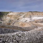
The potential treatment of pits and stockpiles may seek to reflect the existing landscape context as far as possible, while ensuring compliance with safe geotechnical constraints. For example, new crests would be no higher than existing elevations in the immediate vicinity; side slopes would be no steeper than existing gradients and avoid flat areas on visible ridges; and straight angular profiles would be minimized in order to achieve varied and rounded shapes, in particular on visible parts.
The aim should be to carry out progressive working and restoration over the shortest timescale possible, to avoid excessive areas of disturbance. Ideally, this should use direct placement of material. Historic mapping data may be used to reinstate field patterns during restoration.
Three-dimensional modelling and photomontages can allow perspective views of the development to be generated and effects and options tested, such as the location and dimensions of the working face and exposed surfaces relative to intervening landscape features.
Case Study – Measham Brickworks
In July 2007 Leicestershire County Council granted planning permission for the development of land at Hanson’s brickworks in Measham. The state-of-the-art facility covers approximately 60ha and accommodates all manufacturing processes within a new steel portal-framed building, and includes the extension of the mineral workings into arable land, with new crushing facilities, feed hoppers and storage bays and an enclosed conveyor bridge over Atherstone Road linking the workings and the brickworks.
SLR provided the original planning application and full environmental impact assessment, with post-submission support and, after granting of the planning consent, a suite of detailed schemes pursuant to conditions and assistance during their implementation.
Although the scheme pre-dates the GLVIA3 and NPPF technical guidance, it provides a good example of a best-practice approach to landscape mitigation, including:
- Merging the development with the surrounding landscape character (defined as ‘Coalfields Village Farmland’), providing wildlife corridors and helping to achieve the aims of the National Forest.
- Management of existing perimeter hedgerows around the site to provide screening.
- Additional landscape screening mounds for the mineral extraction area, brick factory and conveyor hopper facilities, located at key positions, such as alongside the public highway.
- Additional landscape planting for the mineral extraction area, brick factory and conveyor hopper facilities, including more than 7,000 trees and shrubs planted over two seasons (2009 and 2011).
- Long-term potential replacement of the existing Lombardy poplar tree screens with more appropriate native tree and shrub planting.
- Cladding of the conveyor crossing over the public highway to match the traditional brick colour of the area.
- Ecological enhancement and monitoring of Jubilee Area, a separate piece of land which acted as a receptor area for the translocation of great crested newts, with 3,000 trees and shrubs planted in 2008.
- Phased extraction of clay and direct placement of overburden and other site-derived materials to allow progressive restoration around the margins of the void.
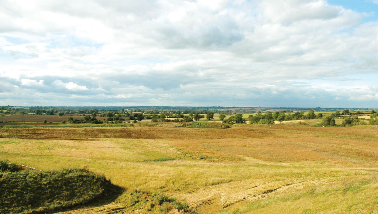
- Final restoration scheme for the end of the circa 20-year quarry workings, incorporating a water body, marginal wetland habitats and further woodland and scrub planting.
Conclusions
Overall, as the technical guidance for NPPF confirms, ‘co-ordination of phasing, provision of temporary or permanent screening, and progressive reclamation can together minimize visual impact and the impact on landscape quality’. The new GLVIA3 provides a useful document for operators and their advisors on how such matters can be incorporated into quarry schemes. For further information visit: www.slrconsulting.com
Bibliography
- LEE, R: ‘Delivering landscape-scale habitat restoration and creation through spatial planning’, RSPB Planning and Regional Policy Team, 2010.
- SWANWICK, C: ‘Guidelines for Landscape and Visual Impact Assessment (3rd Edition)’, Landscape Institute and Institute for Environmental Management and Assessment, 2013.
- TURNBULL, M: ‘GLVIA – date of implementation’, email announcement from chair of the Landscape Institute Technical Committee, 2013.
- UK Government – Department for Communities and Local Government, The National Planning Policy Framework (NPPF), 2012.
- Subscribe to Quarry Management, the monthly journal for the mineral products industry, to read articles before they appear on Agg-Net