The Use of Drones to Improve Quarry Safety and Survey Efficiency

First published in the March 2017 issue of Quarry Management as Clear Lines of Flight
Building the future of quarry monitoring – using drones to boost site safety and survey efficiency
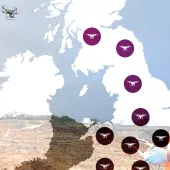
In 2015, French quarry operators Groupe CB turned to drone data analytics experts Redbird to provide accurate, cloud-based geospatial data across nine of their sites. This new, aerial approach led to a major improvement in on-site safety, a five-fold reduction in survey costs, plus an increase in the depth of Groupe CB’s topographic data, providing a clear vision of the future of quarry data management.
Groupe CB (Carrières du Boulonnais) have been exploiting minerals through industrial processing for more than four generations and are major players in industrial and public works, as well as owners of the largest individual quarry in France.
Slow and dangerous work
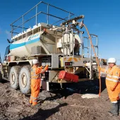
The crucial work of Groupe CB’s surveying teams is to survey stockpiles at each of the company’s quarries and to monitor the height of the faces at each quarry to ensure compliance with local safety regulations. Traditionally, this would have been achieved by surveyors traversing these sites with terrestrial GPS equipment in order to measure the required X, Y, Z data. However, this approach was a dangerous undertaking for these staff.
Therefore, in 2015, Groupe CB decided to try a different approach: they partnered with Redbird, a company specializing in quarry data analytics that would conduct aerial drone surveys of nine Groupe CB quarries each month, before providing the full dataset for each site within 24h, fully accessible online via Redbird’s cloud solution.
‘In the past, monitoring our quarries used to be a complex job,’ explained Vincent Amossé, deputy chief executive officer of Groupe CB’s Aggregates Division. ‘We started working with Redbird because of their reliable, user-friendly cloud data interface and out of concern for the safety of our surveyors.’
Prior to Redbird and drone technology being employed, Groupe CB’s topographers would typically only conduct a full survey of each site once or twice a year. ‘Our topographers were walking around on site and taking their measurements manually, with GPS instruments. This was a long, dangerous and expensive process,’ said Mr Amossé. ‘Now these staff no longer need to go on site as Redbird can monitor the nine quarries safely, from remote take-off and landing locations, and simultaneously, on the same day every month. It’s a progressive approach. We say that together we are building the future of quarry monitoring.’
Flying monthly
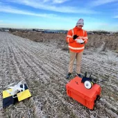
To survey each of these quarries located across France, Redbird employ professional, independent senseFly eBee drone operators – members of their growing international network.
‘These contractors fly each quarry on the same day each month, using the same flight plan within the drone’s eMotion ground-station software,’ explained Emmanuel de Maistre, chief executive officer and co-founder of Redbird. ‘These operators then upload the drone’s images to the Redbird cloud solution (previously called Cardinal), where they are processed into full 3D point clouds, digital surface models, slope maps and orthomosaics of each site.’
Accessible data
As per Redbird’s contract with Groupe CB, the data from each monthly drone survey must be fully accessible online just 24h later.
‘This approach provides fast data recovery and, therefore, incredible time savings,’ said Vincent Amossé. ‘Before working with Redbird we needed about five days to recover stockpile data. Today, once the drone has flown over a quarry, I’ll get the data the next morning. A site manager can then log in to the Redbird solution to access all the data they need, such as stockpile volumes and material types. Then we check these against production and sales to understand exactly what product has gone out, as well as to determine an exact stock value.’
The data supplied via Redbird’s cloud are employed by a wide range of Groupe CB staff, who log in directly online, taking distance, volume and area measurements, including elevation profiles (exportable as shapefiles or .dwg files), adding annotations, attaching supplementary documents and comparing maps.
These staff include:
- Groupe CB’s chief finance officer and accountability team
- Blasting operations staff who need to track the progress of blasting operations (for example, by calculating extraction volumes and monitoring quarry faces)
- Environmental officers who need to ensure environmental standards for local authorities
- Safety managers whose job it is to ensure compliance.
Each quarry’s monthly drone flight typically lasts around 30 minutes. Flights are flown at a height of approximately 100m, to achieve typical ground resolutions of between 3.5cm and 4cm per pixel.
‘It is important to get the highest resolution possible with the drone to ensure the most accurate data and site survey we can,’ pointed out Emmanuel de Maistre.
Weather wise, he added, the ideal wind conditions for flying are between zero and 6m/s. ‘A sunny day is best, without any clouds or grey skies, in order to get the very best quality images.’
Key challenges
According to Mr de Maistre, Redbird’s big challenge is delivering Groupe CB’s data to the cloud just 24h after the flight. ‘From the moment the images are captured and transferred to the cloud, we need to turn them into actionable data within a day,’ he said.
‘Another challenge facing our team has been getting exactly the right high-quality pictures, using the correct camera settings, in order to be able to quickly and easily process these images,’ he added.
Redbird also set ground control points (GCPs) alongside their eBee data acquisitions in order to maximize the precision of their drone outputs. ‘We have placed 77 GCPs across the client’s nine sites – 25 of which are used as check points – all measured with a Trimble GPS RTK device. These are then identified in the drone dataset once the photos have been processed. Through this approach, our final planimetric and altimetric precision is less than 3cm, which is survey-grade accuracy,’ said Mr de Maistre.
Positive results
Traditional surveying methods required a lot of manpower to collect the data required; work that was both dangerous and expensive. In addition, processing this data was highly time-consuming.
‘In contrast, today with UAVs, you need less manpower because you get data from the sky,’ said Vincent Amossé. ‘And it is available as actionable data directly in the Redbird solution 24h hours later – and not only for one site, but for all nine sites. We get a lot more points per square metre with the drones and, therefore, achieve a far greater reliability, both of the quarry surveys and stockpile volumes. The data Redbird supply is completely trustworthy.’
According to Mr Amossé, from a cost perspective, the drone difference is equally remarkable. ‘Our projects carried out using UAVs are five times cheaper than those done using traditional survey methods. It’s as easy as child’s play for us and it is radically changing our way of working.
‘Now we know how to get the best from our quarry faces, and whether or not to modify the layout of our haul roads to improve road safety, and all of this information is available easily and instantly in the cloud,’ he added. ‘Drone data processing is a technology that, I’m sure, quarries all over the world will come to adopt, because it is so simple, reliable and safe. A drone flying over the quarry face allows our blasting operators to precisely define where to drill without going close to the edge. They can stay at a safe distance and the result is a lot more accurate than laser scanning.’
‘Group CB’s story is a great example of the value that Redbird and drone technology brings. With our dedicated, collaborative cloud solution and network of professional eBee operators, we’re helping contractors and mining companies across the Europe, Middle East and Africa region, and the US, to improve their day-to-day operations with drone imagery,’ said Redbird’s Emmanuel de Maistre.
Editor’s note: Prior to publication of this article, Redbird were acquired by Airware.
- Subscribe to Quarry Management, the monthly journal for the mineral products industry, to read articles before they appear on Agg-Net.com