Passive Seismic Surveying
First published in the March 2017 issue of Quarry Management
A new and cost-effective site-assessment tool for the quarrying industry
By Dave J.R. Morgan1, Michael G. Raines1, Stephen Thorpe1, Silvia Castellaro2, Eddie Bailey3 and Philip R. Wilby1
Good quarry design and efficient operation depend upon a ground model that reliably defines the quality, volume and spatial distribution of resource and waste. Most ground models are based on boreholes, sometimes with additional 2D or 3D control provided by ‘traditional’ geophysical surveys such as microgravity, resistivity and active seismic. However, for logistical and economic reasons, these may not always be practical options for site investigations.
This article showcases ‘passive’ seismic survey as a rapid and versatile alternative means of imaging the subsurface, using the Phase 2 extension area of Aggregate Industries UK Ltd’s Bardon Hill Quarry in Charnwood Forest, Leicestershire, as an example. The technique can be used to generate results comparable to traditional high-resolution seismic refraction surveys, but has the distinct advantage over these (and other geophysical techniques) of not requiring extraneous cables, power supplies or artificial seismic sources. Hence, it can be easily deployed by a single operator even at sites that are sensitive or difficult to access, rendering it an especially cost-effective option for the quarrying industry.
What is passive seismic surveying?
Background seismic noise – both natural and man-made – has traditionally been regarded as a nuisance by geophysicists, but it is now known to contain useful information about the physical character of the subsurface. Passive seismic surveys harvest this noise in order to generate vertical profiles (2D slices) through the ground, with variations in impedance contrast (velocity x density) shown as a colour ramp (fig. 1). The technique can be applied to any setting where softer layers overlie harder substrates – a very common geological situation – and, depending on the nature of the ambient seismic noise and the physical properties of the ground, can resolve features at the very near surface all the way down to several hundred metres depth.
Surveys consist of a series of single-station point recordings, generally arranged into linear transects. These can be of any length and, where organized into an appropriate grid pattern, can be used to generate 3D surfaces of target horizons. The spacing of station points influences resolution, and so the equipment can be used either as a rapid reconnaissance tool, perhaps to help plan a future drilling campaign, or as a detailed site investigation tool, perhaps in areas of particularly complex geology where continuous spatial data are required. Best results are achieved where independent depth control – such as borehole information – is available to calibrate the results.
Equipment
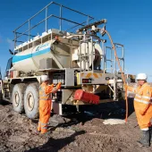
A number of portable passive seismometers are available on the market. The Bardon Hill Quarry survey was conducted using a Tromino instrument (moho.world/tromino/) – a small, broadband, three-component seismometer that utilizes the Horizontal-to-Vertical Spectral Ratio (HVSR) method. It measures background ambient noise and records seismic resonance induced by the presence of sharp impedance (velocity x density) contrasts in the subsurface. Typically, each recording requires the instrument – which is about the size of a lunchbox – to be simply ‘bedded’ securely on to a flat substrate (generally subsoil) for 10–15 minutes; any surrounding vegetation is cleared to eliminate wind-generated interference (fig. 2). Rates of ground coverage vary according to survey design (reconnaissance vs detailed), but about 20 recordings can be reasonably achieved per day, typically amounting to a survey line of one or two kilometres in length.
Test case
The geology of the Phase 2 extension area of Bardon Hill Quarry is complex and has been investigated in an extensive drilling campaign. Hard, dense, late-Precambrian igneous and volcaniclastic rocks – the bedrock resource – are buried beneath a cover of softer Triassic mudstones (Mercia Mudstone Group), which are themselves locally overlain by a varied suite of unconsolidated glacial and post-glacial superficial deposits (drift). Tests at nearby Blackbrook Reservoir, where an earlier traditional seismic survey was conducted, indicate that the Precambrian rocks and the Mercia Mudstone Group have very different seismic properties (approximate P-wave velocities of 5.4km/s and 1.8km/s respectively). This generates a significant impedance contrast across their boundary – exactly what passive seismic surveys depend upon.
Sections in the current (active) Bardon Hill Quarry show the upper surface of the Precambrian rocks to be markedly irregular, consisting of a network of deep channels infilled by the Mercia Mudstone Group (fig. 3). Hence, the thickness of cover and the depth to the bedrock resource varies greatly over short distances; locally, the Precambrian rocks even project through the cover succession and form isolated outcrops. Such complexity is ideal for showcasing the potential contribution of passive seismic surveys to ground modelling. Drilling on its own might not be everywhere able to fully resolve (at least practically) the geology, especially if the complexity occurs on a smaller scale than the boreholes can reasonably be spaced: the geophysical technique offers a means of increasing resolution and reducing uncertainty by filling the gaps with continuous data.
The test case survey made use of two closely calibrated instruments, and comprised 216 station points. These were spaced at an average distance of approximately 40m and were organized into 18 NW–SE orientated transects (fig. 4). Data were acquired for 12 minutes at each station point, which, wherever possible, were sited at borehole locations in order to provide absolute depth calibration for the geophysics. Processing and spectral analysis were carried out in the office using proprietary software, taking an average shear wave velocity (Vs) of 750m/s for the cover sequence (the combined Mercia Mudstone Group and drift) based on the results of three test transects with good borehole control. Two anomalous records – coinciding with recently disturbed soft ground and thick mulch – were excluded. Two-dimensional profiles for each transect were generated by plotting Log H/V (horizontal/vertical components of the seismic noise) relative to elevation (metres above Ordnance Datum) and station point position, with red and mauve colours (peak Log H/V values) representing maximum impedance contrast.
Revealing all….nearly
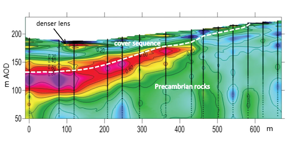
Persistent zones of markedly increased impedance contrast are conspicuous features of all of the 2D profile sections from the Phase 2 extension area of Bardon Hill Quarry, and their general shape conforms to the expected channelized form. Hence, the technique is able to faithfully capture even highly irregular surfaces, in this case at least down to a depth of 90m. In addition, the technique provided clues as to the nature of the boundary between the Precambrian rocks and the Mercia Mudstone Group: the abruptness of the increase in impedance contrast implies a sharp boundary, without intervening boulder beds. This is in apparent agreement with the borehole evidence and with exposures in the existing (active) quarry.
However, the technique failed to clearly define the margins of the channels where the Precambrian rocks lie at or very near the present ground surface, because there is no potential for an appreciable impedance contrast in these areas. Small, horizontal zones of high impedance contrast within the upper parts of several of the 2D profile sections likely correspond to lenses of denser material within the cover of superficial deposits, or hard bands (so-called ‘skerries’) within the Mercia Mudstone Group, both of which might prove important considerations during quarry planning.
3D modelling
Where passive seismic surveys are organized into an appropriate gridded pattern, there exists the potential to model the acquired data in 3D. Significantly, this can allow volumes of resource and overburden to be calculated, or spatial variability within particular units to be mapped. In this test case, the concealed top surface of the Precambrian rocks in the Phase 2 area was modelled using GSI3D v2013, a proprietary 3D modelling software package developed by INSIGHT GmbH in collaboration with the British Geological Survey.
This software simultaneously displays maps, geological boundaries, borehole logs and other spatial information relative to a digital elevation model, allowing the user to correlate surfaces within a grid of defined cross-sections (fig. 5) – in this case the 2D seismic profile sections – and thence build triangulated models of the surfaces by mathematical interpolation between nodes on the sections. The position of the Precambrian rock surface was interpreted in each 2D seismic profile section and digitized, using available borehole information as calibration. The subcrop position (ie beneath the superficial deposits) of the boundary between the Precambrian rocks and Mercia Mudstone Group was taken from the national DigMap10 geological dataset.
The model reveals the upper surface of the bedrock resource to be sculpted into a complex system of deep channels and intervening peaks, which generally descend towards the north-west, where they converge on a broad NE–SW oriented valley, approximately 90m below current ground level (fig. 6). It admirably demonstrates the potential power of passive seismic surveys: the model provides a convincing and more nuanced interpretation of the surface than that based on the boreholes alone, potentially facilitating more detailed planning and resource assessment. Further drilling will allow the model to be tested and refined in those areas of greatest uncertainty, but the ultimate ground-truthing of the geophysics will come when the geology is revealed during the forthcoming ‘muck-shift’.
Good vibes
Geology is rarely simple, so applying average parameters (eg shear wave velocity) to a model could, potentially, introduce unreasonable levels of uncertainty. Site-specific variations in the composition, structure and overall thickness of units will each affect seismometer response, and cannot be quantified without independent physical property information (eg density, fracturing). Even so, passive seismic surveys have been shown to provide valuable insights into a very wide range of geological ground conditions, particularly when used in conjunction with drilling or other means of independent depth calibration. In recent trials by the British Geological Survey, the technique has been used to: detect and characterize buried hollows, locate faults and fracture zones, assess sand and gravel thicknesses, and determine the structure of dipping strata. This versatility, together with the efficiency of ground coverage and the potential penetration depth, combine to make the technique a powerful, but as yet largely unexplored, potential tool for the quarrying industry.
For further information, contact Phil Wilby at the British Geological Survey on tel: (0115) 936 3602; or email: prwi@bgs.ac.uk
Notes on the authors
- British Geological Survey, Environmental Science Centre, Nicker Hill, Keyworth, Nottingham NG12 5GG.
- Department of Physics & Astronomy, University of Bologna, Viale Berti Pichat 8, 40126 Bologna, Italy.
- Aggregate Industries Ltd, Bardon Hall, Copt Oak Road, Markfield, Leicestershire LE67 9PJ.
- Subscribe to Quarry Management, the monthly journal for the mineral products industry, to read articles before they appear on Agg-Net.com