Rock on! Getting the Best from Archaeology
First published in the August 2022 issue of Quarry Management
How a contribution to archaeology can help the minerals industry gain the recognition it deserves
By Clive Waddington, managing director, Archaeological Research Services Ltd
Minerals extraction and archaeology have a long history with references to a multitude of discoveries during quarry operations from the 19th century onwards. This should not be a surprise, because both pursuits rely on excavating the ground and creating value by what they extract from it. In short, geologists and archaeologists have a lot in common with a shared passion for the ground under their feet, what is in it, how it formed, how old it is, how it can be studied, what it can be used for, and how we can best use its fruits and support our livelihoods from it.
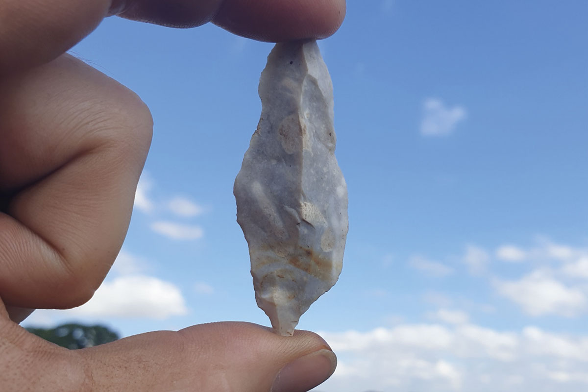
We share an interest and knowledge of stratigraphy, lithology, rock types, soil types, geochemical properties, as well as an interest in how people exploited the ground in the past and what we can learn, or benefit from, today. The earliest humans used tools made from flint and chert, often quarried from the ground, or in the case of the high-quality flint used in Neolithic Britain (from around 4000 BC) mined flint from dedicated flint mines, such as those at Grimes Graves in Norfolk, or at Blackpatch on the South Downs. For good reason, mineral extraction is often referred to as ‘the oldest industry’.
The way in which archaeology is undertaken as part of the planning systems in Britain is not without its problems, but it is essential not to lose sight of the huge benefits and good work that has been achieved over the last 30 years. As quarries and other large-scale developments tend to take up large footprints, the ability to discover types of archaeological remains that had previously been seldom found has increased. Quarrying has revealed evidence of Neolithic settlements, Bronze Age settlements, and Anglo-Saxon sites, which had been very poorly documented up until then. Similarly, Palaeolithic archaeology has been found on several sites in the Midlands and southern England, whilst Bronze Age artefacts have been found on sites around the Trent valley.
Public engagement
There has been great public engagement with much interest created throughout the UK and beyond, together with media coverage, school visits, improved access, and participation benefits for the local communities in which they are situated. This has gone some way to improving knowledge and perception of the minerals industry and the great work it does for the natural and historic environment. Archaeology is a huge draw, and it provides an area where the minerals industry can realize more benefit for itself by its inclusion in sustainability and ESG indicators, whilst also using it as a vehicle to orientate much public engagement work.
The challenges though, must not be avoided. Perhaps the key challenge has been the longstanding scope creep by some mineral planning authorities, with some requesting ever-larger percentages of evaluation trenching as part of pre-application works. Over the last decade or so, and with the rapid advances in modern technology, new approaches are providing opportunities to undertake better, faster, and cheaper evaluation, all of which need to be orientated around a question-led and targeted approach. A short case study on Tarmac’s Killerby Quarry is described below.
Killerby case study
Killerby Quarry is a new sand and gravel quarry in North Yorkshire that together with an extension to previous workings at Ellerton encompasses an area of c.200ha next to the A1 trunk road immediately south and east of several Scheduled Monuments around Catterick. Rather than undertake large-scale geophysics and high-percentage evaluation trenching across this hummocky landscape, a more thought-out approach was adopted. It was orientated around what has been termed the ‘landform element’ approach, whereby the land parcel was mapped according to the varying landforms that comprised the development area. In this case, much of the lands were morainic deposits that included a range of ice wastage features and relict wetlands, together with sand and gravel ridges and a Holocene alluvial valley floor with palaeochannels inset within it.
A targeted programme of sediment coring, radiocarbon dating, and pollen assessment was undertaken on the various relict wetland deposits, together with high-resolution field-walking, detailed Lidar and aerial photographic analysis and mapping, with only a very small quantity of geophysical survey and targeted evaluation trenches. It became clear that the most significant questions that surviving remains on this site could answer were associated with the Late Glacial and Early Holocene periods – that of the hunter-gatherer groups. This is a period about which very little is currently known, and remains of this age are rare.
However, the outcome of this was that there were not believed to be any remains present that could preclude development, and a robust and innovative scheme of mitigation was agreed prior to submission of the application. This meant that all stakeholders understood what would be required from the outset, rather than leaving negotiation of the mitigation until after permission was granted. Following the granting of permission for this new quarry the mitigation focused on the careful sample excavation of a series of relict wetland features – the first time any features like this had been investigated from a purely archaeological perspective, with the specific intention of recovering remains of the early Postglacial hunter-gatherers.
Sure enough, the results proved to be a real first with the discovery of the remains of three tepees, one with the fireplace still inside, which have been dated to the Early Mesolithic some 11,000 years ago. If this was not enough, a kettle hole produced, amongst other remains, a large timber platform built out into a small pond for use, we think, as a tanning pit – so that the skins of wild cattle and other animals could be processed for uses such as clothing, tent coverings, bags, and more. The presence of palaeoenvironmental remains around these structures meant that the past vegetation could also be reconstructed, adding further to understanding how people adapted to, and exploited, their surrounding environment at these times.
In addition, other archaeological remains have been found, including Neolithic and Bronze Age pits, a later Iron Age-Romano-British settlement, and an Anglo-Saxon midden. However, most of the resources were focused on the hunter-gatherer archaeology, which has contributed most to gaining new knowledge and understanding. Overall, the pre-application evaluation cost significantly less than a standard geophysical survey followed by an evaluation trenching approach, and rare archaeology was found that the standard approach would almost certainly have missed. The message here is that solutions are out there, but early planning is essential.
Hope Shale Quarry case study
A second case study is Breedon’s Hope Shale Quarry, where a focus on public engagement helped deliver a highly informative and value-added piece of mitigation work in a National Park setting – a challenging place for mineral extraction at the best of times. Here, as the archaeological excavation was taking place on the edge of the Roman fort of ‘Navio’, a Scheduled Monument, it was thought that additional value could be created by the opportunity for local volunteers to get involved with the excavation works. In the event around 70 volunteers contributed to the excavation. A short video was made that attracted 147,000 views on social media[1] and the site featured on BBC’s Digging for Britain.
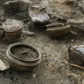
The archaeological investigation revealed the remains of parts of the fort’s vicus (external settlement), together with its defensive ditch, ballista balls, as well as large quantities of pottery, several coins, leather shoes, gaming pieces, galena, and some small, moulded lead fragments and other remains. One of the key findings resulted from the use of innovative technology (portable XRF) that allowed the identification of a lead-processing area, indicating the role of the fort in controlling Roman lead extraction, processing, and exchange from the Peak District out to the rest of the Roman empire. The lead ‘pigs’ from the Peak District have ‘Lutudarum’ stamped on them, and these have been found in North Africa, the Levant, Greece, Italy, Spain, and elsewhere. The precise location of Lutudarum has not yet been pinpointed, but the excavations at Hope have helped shed light on an international story involving early mineral extraction and trade that was essential to Roman civilization and a key source of this mineral for the rest of the entire empire.
Conclusion
With just these two short case studies, amongst many others that could be given, measuring archaeological contribution has to be a useful priority for the minerals industry to action, so that it can tell itself, its stakeholders, and the public what it achieves year on year, so the industry gains the recognition it deserves.
REFERENCE
- Subscribe to Quarry Management, the monthly journal for the mineral products industry, to read articles before they appear on Agg-Net.com