Blow Away The Cobwebs
Martin Millmore, director of The Mineral Planning Group, discusses an imaginative approach to quarry restoration design
Quarry restoration schemes are an integral part of planning applications and are just as important as the quarry itself. In terms of the site, the quarry life is relatively short term and it is the restoration that will continue into the future, defining the landscape. This can be easily overlooked when the main focus is on the size and value of the deposit.
There are, however, many aspects that need to be taken into account when designing a restoration scheme:
- is it financially viable in terms of landscaping, planting and maintenance?
- will the land be returned to a level of quality that either matches or surpasses its current state?
- will it be accepted by the mineral planning authority (MPA) and local communities?
The majority of quarry restoration schemes tend to be designated areas of pastureland and/or a section set aside for nature conservation, which is an acceptable option that pleases MPAs and local communities. Unfortunately, because this option is so acceptable, it has often become standard and imaginative thinking has been put to one side. People have become unconcerned and settle for the ‘safe’ option, forgetting that exhausted quarries are basically blank canvases that have huge potential and are ‘screaming out’ to have some lateral thinking lavished on them.
Restoration schemes create opportunities to do something unique and interesting with an area of land that not only meets the policies set by local authorities, but also creates positive interest from the general public. By investigating local interests, history, archaeology, culture etc, and intertwining elements of these within the restoration scheme, a more positive attitude towards mineral development can be created, avoiding isolation from local communities.
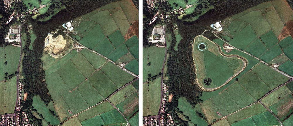
An example of an extension to an existing dimension stone quarry, including local interests within a restoration scheme, is a recent application developed by The Mineral Planning Group (MPG) that looked at the archaeological features found within the local area.
After discovering that a relation of the landowner was an amateur archaeologist who had found examples of ‘cup and ring’ stones on adjacent land, a new concept was created for the restoration design.
Cup and ring stones are a range of rock-carved symbols that are found mainly in northern England and Scotland and are estimated to be in the region of 4,000 and 5,000 years old, dating back to the Neolithic and Bronze Ages. The carvings are generally made up of circular hollows surrounded by circular channels and linked together by lined grooves. It is believed that they were possibly used for religious and ritual purposes.
Also found in the region are very large henges, which were incorporated within the cup and ring design. The idea was to create archaeological ‘art in the landscape’ based on the cup and ring design, with three main circular features linked together with drystone walls within a triangular field structure. The three circles will be made up of concentric circles, in keeping with the cup and ring designs, and will be raised above ground level to make them more prominent, like a henge. As the design is on the quarry floor, approximately 10m below the surrounding ground level, members of the public will be able to observe the whole design from an adjacent footpath, as well as walk around the site.
Once the design had been decided upon, the next step was to incorporate a range of habitat types to try to create an ecological hub that would link up with the adjacent woodland. The land is currently open fields used for cattle grazing, with only a few habitat types and low biodiversity. By incorporating a variety of additional habitats within the design MPG have been able to create a scheme that will encourage the number of species to increase from its current status.
Quarry mineral waste provides the most suitable material for building conservation zones. If soils are removed and separated in an appropriate manner they can provide a rich, fertile base for planting grasses, shrubs and trees without the need for fertilizers. The remaining overburden and interburden can be used to re-contour the site and build raised features within the design. In this case the waste material is to be used to build the henges with large standing stones to be positioned in the centre of the two southern henges as well as within the drystone wall surrounding the northern henge.
The central field within the design and the land at the top of the quarry face will be designated as open pastureland for cattle, allowing the farmer to continue using the land. The remaining land surrounding the triangular enclosure and henges will be designated as wild pasture, leaving plants and shrubs to create a natural habitat. By allowing cattle to graze in the open pasture the grass will be kept short, maintaining the triangular shape’s visual prominence. By allowing the outer land to grow wild, there will be few, if any, maintenance costs.
All three of the henges have different characteristics, which in turn will attract a variety of different species.
The large blocks of quarry waste used to create the south-west henge will be strategically positioned to create tunnels within the henge. These can be used as artificial badger setts. Planted on top of the henge will be alternating concentric rings of various species of deciduous trees. These will not only create a variety of habitats for birds, mammals and insects, but also maintain the concentric ring design with seasonal variations in colour throughout the year.
The henge to the south-east has been designed as open grassland with concentric drystone walls, which will create a habitat for small mammals and birds. Each of the rings will be raised to different levels, the middle circle being the highest and the outer circle being the lowest, with grass ramps linking the different levels. This henge will be left open for cattle to roam around, which will ensure the grass is kept short.
The contours of the restored site will gently slope towards the north to control the directional flow of rainwater run-off. A trench, much like a moat, surrounding the northern henge will be used as a water trap to create an ephemeral pond and will become the outer ring of the concentric circle design. This will allow a variety of aquatic species, such as newts and frogs, to take up residence, which in turn will attract a variety of birds and mammals. The remaining circles will be made up of aquatic reeds, evergreen trees and deciduous trees, each creating a different habitat and also maintaining the concentric circle design throughout the year, again changing with the seasons.
Within all the tree groupings and on the open quarry faces, specially designed bird and bat boxes will be introduced to encourage nesting and roosting. Positioned at the base of the final quarry faces, on the south side of the site, large piles of rock debris will create ‘refuges’ for small mammals and insects as well as creating adjacent feeding grounds for foxes and raptors.
The main aim of the restoration concept is to create an interesting variety of uses that can work in conjunction with each other and require as little maintenance as possible. The site is designed in such a way that a range of people can use it. The open pastureland in the centre can still be utilized by the farmer, while the variety of wildlife should attract birdwatchers, wildlife enthusiasts, school trips etc. The exposed rock faces from the quarry will facilitate studies by geologists and the general design of the site will attract members of the public who want to go for a walk. Instead of simply returning the site back to grazing land with a bit of conservation it should become a subtle tourist attraction, which will hopefully create a number of knock-on effects. People who come from further afield to see the site may end up spending more time in the area, frequenting local shops and tourist attractions and justifying a stay in a bed and breakfast, all of which would be beneficial to the local community.
The possibilities for imaginative quarry restoration design are endless and each one can be unique to its surroundings. The example discussed in this article came about purely through looking at local interests for inspiration. The only question is ‘will the local planning authorities be willing to take a risk and go for something different?’ Initial discussion with MPA officers has been encouraging. It was thought they would give the scheme an early ‘thumbs-down’, but they were found to be both imaginative and enthusiastic about the concept.
If the application is approved, MPG hope that it might be the start to a new way of designing restoration schemes and, ultimately, contribute to the overall acceptance of new mineral workings by MPAs and local communities. It has the potential to become the deciding factor between approval and refusal and, with the odds already stacked against mineral applications, opportunities for new approaches to final restoration designs should not be dismissed.